You are here: Home > Network List > XJ13 - CRAFTI Stations List
> Station LL23 Sali PS > Earthquake Result Viewer
LL23 Sali PS - Earthquake Result Viewer
| Earthquake location: |
Southern Molucca Sea |
| Earthquake latitude/longitude: |
-0.2/125.2 |
| Earthquake time(UTC): |
2014/09/10 (253) 02:46:06 GMT |
| Earthquake Depth: |
30 km |
| Earthquake Magnitude: |
6.2 MWW, 6.1 MWB, 6.5 MI |
| Earthquake Catalog/Contributor: |
NEIC PDE/NEIC COMCAT |
|
| Network: |
XJ CRAFTI |
| Station: |
LL23 Sali PS |
| Lat/Lon: |
2.30 S/35.69 E |
| Elevation: |
1257 m |
|
| Distance: |
89.5 deg |
| Az: |
267.72 deg |
| Baz: |
90.164 deg |
| Ray Param: |
0.04178723 |
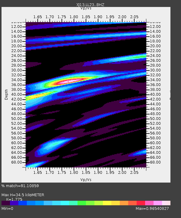
| Estimated Moho Depth: |
34.5 km |
| Estimated Crust Vp/Vs: |
1.77 |
| Assumed Crust Vp: |
6.576 km/s |
| Estimated Crust Vs: |
3.705 km/s |
| Estimated Crust Poisson's Ratio: |
0.27 |
|
| Radial Match: |
91.10859 % |
| Radial Bump: |
400 |
| Transverse Match: |
81.72484 % |
| Transverse Bump: |
400 |
| SOD ConfigId: |
3390531 |
| Insert Time: |
2019-04-13 23:04:01.443 +0000 |
| GWidth: |
2.5 |
| Max Bumps: |
400 |
| Tol: |
0.001 |
|

Signal To Noise
| Channel | StoN | STA | LTA |
| XJ:LL23: :BHZ:20140910T02:58:29.140002Z | 1.2413648 | 1.0356039E-7 | 8.3424624E-8 |
| XJ:LL23: :BHN:20140910T02:58:29.140002Z | 0.91790336 | 9.5555336E-8 | 1.0410173E-7 |
| XJ:LL23: :BHE:20140910T02:58:29.140002Z | 1.561103 | 1.8207889E-7 | 1.1663477E-7 |
| Arrivals |
| Ps | 4.2 SECOND |
| PpPs | 14 SECOND |
| PsPs/PpSs | 18 SECOND |


