You are here: Home > Network List > US - United States National Seismic Network Stations List
> Station LONY Lake Ozonia, New York, USA > Earthquake Result Viewer
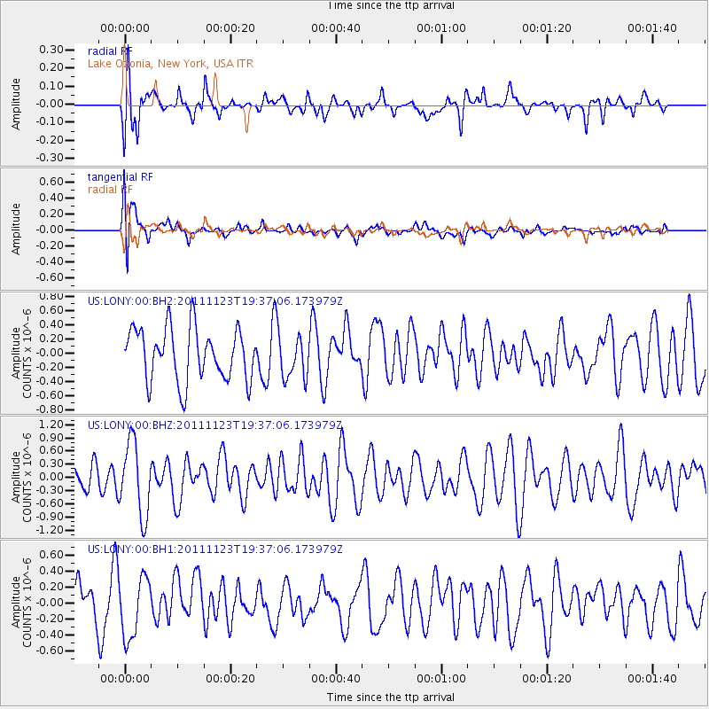
LONY Lake Ozonia, New York, USA - Earthquake Result Viewer
*The percent match for this event was below the threshold and hence no stack was calculated.
| Earthquake location: |
Near East Coast Of Honshu, Japan |
| Earthquake latitude/longitude: |
37.4/141.4 |
| Earthquake time(UTC): |
2011/11/23 (327) 19:24:31 GMT |
| Earthquake Depth: |
34 km |
| Earthquake Magnitude: |
5.7 MB, 5.8 MS, 6.1 MW, 6.1 MW |
| Earthquake Catalog/Contributor: |
WHDF/NEIC |
|
| Network: |
US United States National Seismic Network |
| Station: |
LONY Lake Ozonia, New York, USA |
| Lat/Lon: |
44.62 N/74.58 W |
| Elevation: |
440 m |
|
| Distance: |
92.2 deg |
| Az: |
24.807 deg |
| Baz: |
332.089 deg |
| Ray Param: |
$rayparam |
*The percent match for this event was below the threshold and hence was not used in the summary stack. |
|
| Radial Match: |
56.05641 % |
| Radial Bump: |
400 |
| Transverse Match: |
58.481083 % |
| Transverse Bump: |
400 |
| SOD ConfigId: |
558545 |
| Insert Time: |
2013-09-19 07:13:29.812 +0000 |
| GWidth: |
2.5 |
| Max Bumps: |
400 |
| Tol: |
0.001 |
|
Signal To Noise
| Channel | StoN | STA | LTA |
| US:LONY:00:BHZ:20111123T19:37:06.173979Z | 2.552291 | 8.378144E-7 | 3.2825977E-7 |
| US:LONY:00:BH1:20111123T19:37:06.173979Z | 1.3106474 | 3.7833823E-7 | 2.8866518E-7 |
| US:LONY:00:BH2:20111123T19:37:06.173979Z | 0.8010038 | 2.9874323E-7 | 3.7296107E-7 |
| Arrivals |
| Ps | |
| PpPs | |
| PsPs/PpSs | |


