You are here: Home > Network List > XJ13 - CRAFTI Stations List
> Station PR31 Engaruka Boma > Earthquake Result Viewer
PR31 Engaruka Boma - Earthquake Result Viewer
| Earthquake location: |
Southern Molucca Sea |
| Earthquake latitude/longitude: |
-0.2/125.2 |
| Earthquake time(UTC): |
2014/09/10 (253) 02:46:06 GMT |
| Earthquake Depth: |
30 km |
| Earthquake Magnitude: |
6.2 MWW, 6.1 MWB, 6.5 MI |
| Earthquake Catalog/Contributor: |
NEIC PDE/NEIC COMCAT |
|
| Network: |
XJ CRAFTI |
| Station: |
PR31 Engaruka Boma |
| Lat/Lon: |
2.92 S/36.05 E |
| Elevation: |
884 m |
|
| Distance: |
89.1 deg |
| Az: |
267.103 deg |
| Baz: |
90.141 deg |
| Ray Param: |
0.042048637 |
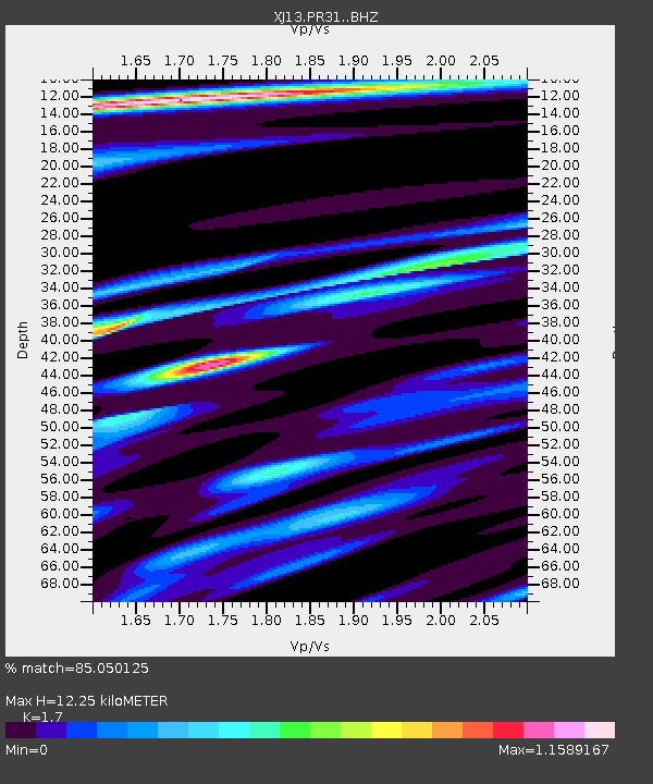
| Estimated Moho Depth: |
12.25 km |
| Estimated Crust Vp/Vs: |
1.70 |
| Assumed Crust Vp: |
6.601 km/s |
| Estimated Crust Vs: |
3.883 km/s |
| Estimated Crust Poisson's Ratio: |
0.24 |
|
| Radial Match: |
85.050125 % |
| Radial Bump: |
400 |
| Transverse Match: |
71.060814 % |
| Transverse Bump: |
400 |
| SOD ConfigId: |
3390531 |
| Insert Time: |
2019-04-13 23:04:05.686 +0000 |
| GWidth: |
2.5 |
| Max Bumps: |
400 |
| Tol: |
0.001 |
|

Signal To Noise
| Channel | StoN | STA | LTA |
| XJ:PR31: :BHZ:20140910T02:58:27.46001Z | 1.4341463 | 1.9098299E-7 | 1.3316841E-7 |
| XJ:PR31: :BHN:20140910T02:58:27.46001Z | 1.0517124 | 1.4167702E-7 | 1.347108E-7 |
| XJ:PR31: :BHE:20140910T02:58:27.46001Z | 1.0217844 | 1.6046846E-7 | 1.5704727E-7 |
| Arrivals |
| Ps | 1.3 SECOND |
| PpPs | 4.9 SECOND |
| PsPs/PpSs | 6.2 SECOND |


