You are here: Home > Network List > II - Global Seismograph Network (GSN - IRIS/IDA) Stations List
> Station KAPI Kappang, Sulawesi, Indonesia > Earthquake Result Viewer
KAPI Kappang, Sulawesi, Indonesia - Earthquake Result Viewer
| Earthquake location: |
Hokkaido, Japan Region |
| Earthquake latitude/longitude: |
41.9/142.6 |
| Earthquake time(UTC): |
2011/11/24 (328) 10:25:34 GMT |
| Earthquake Depth: |
38 km |
| Earthquake Magnitude: |
5.9 MB, 5.8 MS, 6.2 MW, 6.2 MW |
| Earthquake Catalog/Contributor: |
WHDF/NEIC |
|
| Network: |
II Global Seismograph Network (GSN - IRIS/IDA) |
| Station: |
KAPI Kappang, Sulawesi, Indonesia |
| Lat/Lon: |
5.01 S/119.75 E |
| Elevation: |
300 m |
|
| Distance: |
51.1 deg |
| Az: |
209.84 deg |
| Baz: |
21.893 deg |
| Ray Param: |
0.06752411 |
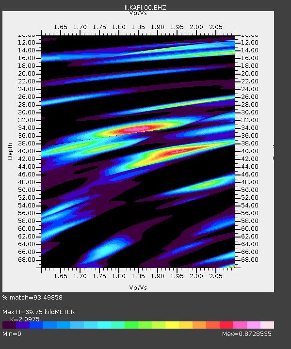
| Estimated Moho Depth: |
69.75 km |
| Estimated Crust Vp/Vs: |
2.10 |
| Assumed Crust Vp: |
6.343 km/s |
| Estimated Crust Vs: |
3.024 km/s |
| Estimated Crust Poisson's Ratio: |
0.35 |
|
| Radial Match: |
93.49858 % |
| Radial Bump: |
400 |
| Transverse Match: |
86.44916 % |
| Transverse Bump: |
400 |
| SOD ConfigId: |
558545 |
| Insert Time: |
2013-09-19 07:15:54.004 +0000 |
| GWidth: |
2.5 |
| Max Bumps: |
400 |
| Tol: |
0.001 |
|
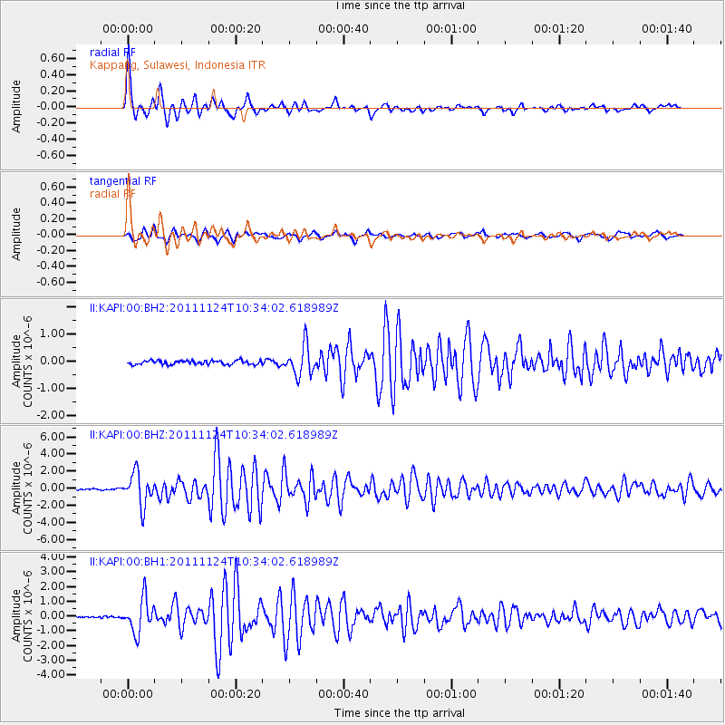
Signal To Noise
| Channel | StoN | STA | LTA |
| II:KAPI:00:BHZ:20111124T10:34:02.618989Z | 17.42738 | 1.8989795E-6 | 1.08965295E-7 |
| II:KAPI:00:BH1:20111124T10:34:02.618989Z | 21.081495 | 1.1423866E-6 | 5.418907E-8 |
| II:KAPI:00:BH2:20111124T10:34:02.618989Z | 7.756302 | 5.581176E-7 | 7.195667E-8 |
| Arrivals |
| Ps | 13 SECOND |
| PpPs | 33 SECOND |
| PsPs/PpSs | 45 SECOND |


