You are here: Home > Network List > US - United States National Seismic Network Stations List
> Station ERPA Erie, Pennsylvania, USA > Earthquake Result Viewer
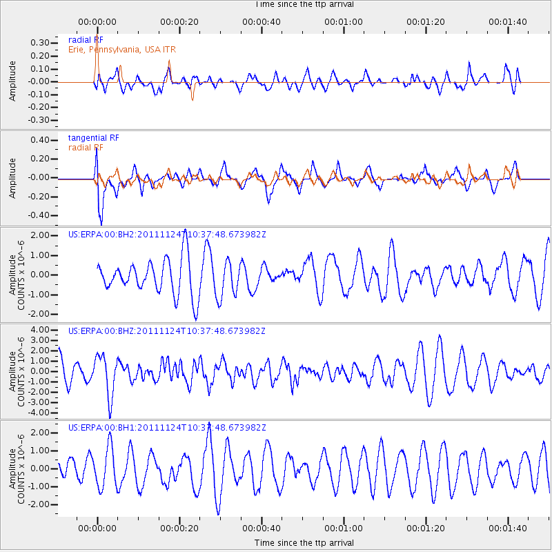
ERPA Erie, Pennsylvania, USA - Earthquake Result Viewer
*The percent match for this event was below the threshold and hence no stack was calculated.
| Earthquake location: |
Hokkaido, Japan Region |
| Earthquake latitude/longitude: |
41.9/142.6 |
| Earthquake time(UTC): |
2011/11/24 (328) 10:25:34 GMT |
| Earthquake Depth: |
38 km |
| Earthquake Magnitude: |
5.9 MB, 5.8 MS, 6.2 MW, 6.2 MW |
| Earthquake Catalog/Contributor: |
WHDF/NEIC |
|
| Network: |
US United States National Seismic Network |
| Station: |
ERPA Erie, Pennsylvania, USA |
| Lat/Lon: |
42.12 N/79.99 W |
| Elevation: |
306 m |
|
| Distance: |
87.9 deg |
| Az: |
30.278 deg |
| Baz: |
329.607 deg |
| Ray Param: |
$rayparam |
*The percent match for this event was below the threshold and hence was not used in the summary stack. |
|
| Radial Match: |
25.482706 % |
| Radial Bump: |
399 |
| Transverse Match: |
63.881344 % |
| Transverse Bump: |
400 |
| SOD ConfigId: |
558545 |
| Insert Time: |
2013-09-19 07:17:43.997 +0000 |
| GWidth: |
2.5 |
| Max Bumps: |
400 |
| Tol: |
0.001 |
|
Signal To Noise
| Channel | StoN | STA | LTA |
| US:ERPA:00:BHZ:20111124T10:37:48.673982Z | 1.8412998 | 1.9867498E-6 | 1.0789931E-6 |
| US:ERPA:00:BH1:20111124T10:37:48.673982Z | 2.224477 | 1.1239905E-6 | 5.05283E-7 |
| US:ERPA:00:BH2:20111124T10:37:48.673982Z | 1.0131977 | 9.086845E-7 | 8.9684823E-7 |
| Arrivals |
| Ps | |
| PpPs | |
| PsPs/PpSs | |


