You are here: Home > Network List > US - United States National Seismic Network Stations List
> Station MNTX Cornudas Mountains, Texas, USA > Earthquake Result Viewer
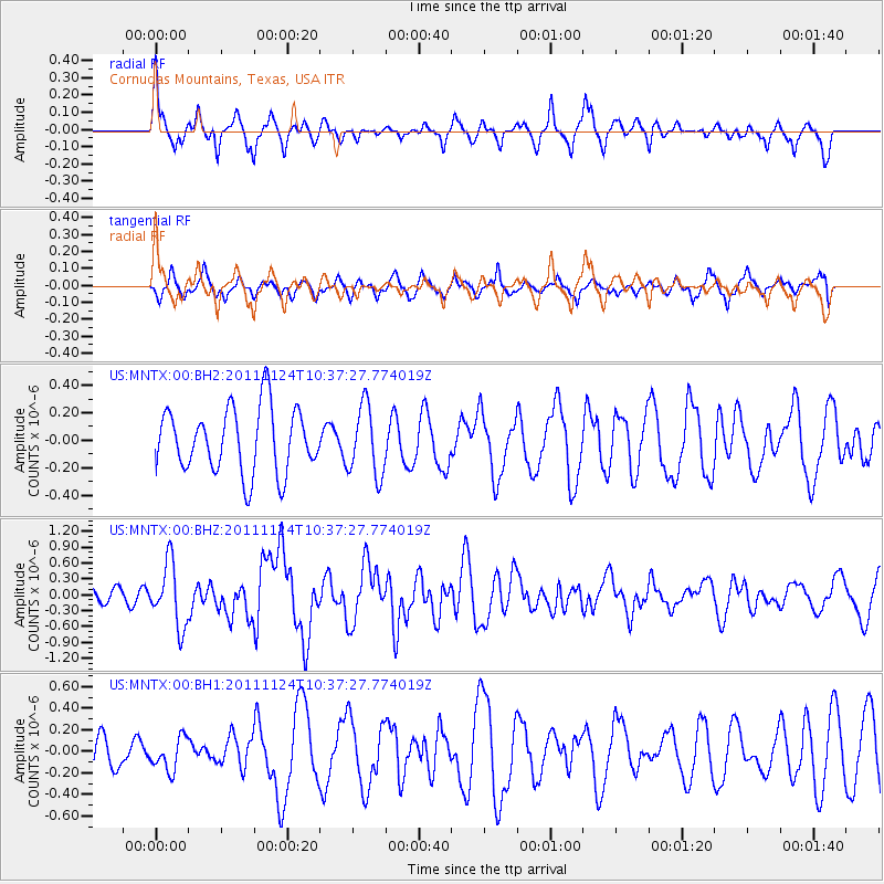
MNTX Cornudas Mountains, Texas, USA - Earthquake Result Viewer
*The percent match for this event was below the threshold and hence no stack was calculated.
| Earthquake location: |
Hokkaido, Japan Region |
| Earthquake latitude/longitude: |
41.9/142.6 |
| Earthquake time(UTC): |
2011/11/24 (328) 10:25:34 GMT |
| Earthquake Depth: |
38 km |
| Earthquake Magnitude: |
5.9 MB, 5.8 MS, 6.2 MW, 6.2 MW |
| Earthquake Catalog/Contributor: |
WHDF/NEIC |
|
| Network: |
US United States National Seismic Network |
| Station: |
MNTX Cornudas Mountains, Texas, USA |
| Lat/Lon: |
31.70 N/105.38 W |
| Elevation: |
404 m |
|
| Distance: |
83.7 deg |
| Az: |
52.679 deg |
| Baz: |
315.853 deg |
| Ray Param: |
$rayparam |
*The percent match for this event was below the threshold and hence was not used in the summary stack. |
|
| Radial Match: |
71.760796 % |
| Radial Bump: |
341 |
| Transverse Match: |
58.33151 % |
| Transverse Bump: |
400 |
| SOD ConfigId: |
558545 |
| Insert Time: |
2013-09-19 07:18:16.635 +0000 |
| GWidth: |
2.5 |
| Max Bumps: |
400 |
| Tol: |
0.001 |
|
Signal To Noise
| Channel | StoN | STA | LTA |
| US:MNTX:00:BHZ:20111124T10:37:27.774019Z | 2.6779017 | 5.951315E-7 | 2.2223799E-7 |
| US:MNTX:00:BH1:20111124T10:37:27.774019Z | 0.887402 | 1.5321929E-7 | 1.7266052E-7 |
| US:MNTX:00:BH2:20111124T10:37:27.774019Z | 1.075054 | 2.529448E-7 | 2.3528565E-7 |
| Arrivals |
| Ps | |
| PpPs | |
| PsPs/PpSs | |


