You are here: Home > Network List > US - United States National Seismic Network Stations List
> Station LKWY Lake (Yellowstone--Lake), Wyoming, USA > Earthquake Result Viewer
LKWY Lake (Yellowstone--Lake), Wyoming, USA - Earthquake Result Viewer
*The percent match for this event was below the threshold and hence no stack was calculated.
| Earthquake location: |
Near Coast Of Peru |
| Earthquake latitude/longitude: |
-14.3/-75.9 |
| Earthquake time(UTC): |
2011/11/27 (331) 19:56:39 GMT |
| Earthquake Depth: |
35 km |
| Earthquake Magnitude: |
5.7 ML |
| Earthquake Catalog/Contributor: |
NEIC PDE/NEIC PDE-M |
|
| Network: |
US United States National Seismic Network |
| Station: |
LKWY Lake (Yellowstone--Lake), Wyoming, USA |
| Lat/Lon: |
44.57 N/110.40 W |
| Elevation: |
2424 m |
|
| Distance: |
66.5 deg |
| Az: |
333.81 deg |
| Baz: |
143.24 deg |
| Ray Param: |
$rayparam |
*The percent match for this event was below the threshold and hence was not used in the summary stack. |
|
| Radial Match: |
29.13715 % |
| Radial Bump: |
400 |
| Transverse Match: |
40.68022 % |
| Transverse Bump: |
400 |
| SOD ConfigId: |
558545 |
| Insert Time: |
2013-09-19 07:21:51.971 +0000 |
| GWidth: |
2.5 |
| Max Bumps: |
400 |
| Tol: |
0.001 |
|
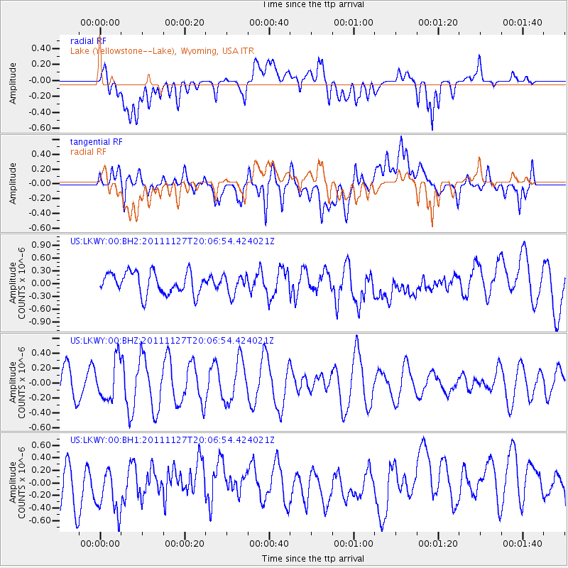
Signal To Noise
| Channel | StoN | STA | LTA |
| US:LKWY:00:BHZ:20111127T20:06:54.424021Z | 1.6194052 | 2.6873337E-7 | 1.6594572E-7 |
| US:LKWY:00:BH1:20111127T20:06:54.424021Z | 1.1675196 | 4.2733612E-7 | 3.6602054E-7 |
| US:LKWY:00:BH2:20111127T20:06:54.424021Z | 0.9086744 | 2.3070604E-7 | 2.5389295E-7 |
| Arrivals |
| Ps | |
| PpPs | |
| PsPs/PpSs | |


