You are here: Home > Network List > II - Global Seismograph Network (GSN - IRIS/IDA) Stations List
> Station PFO Pinon Flat, California, USA > Earthquake Result Viewer
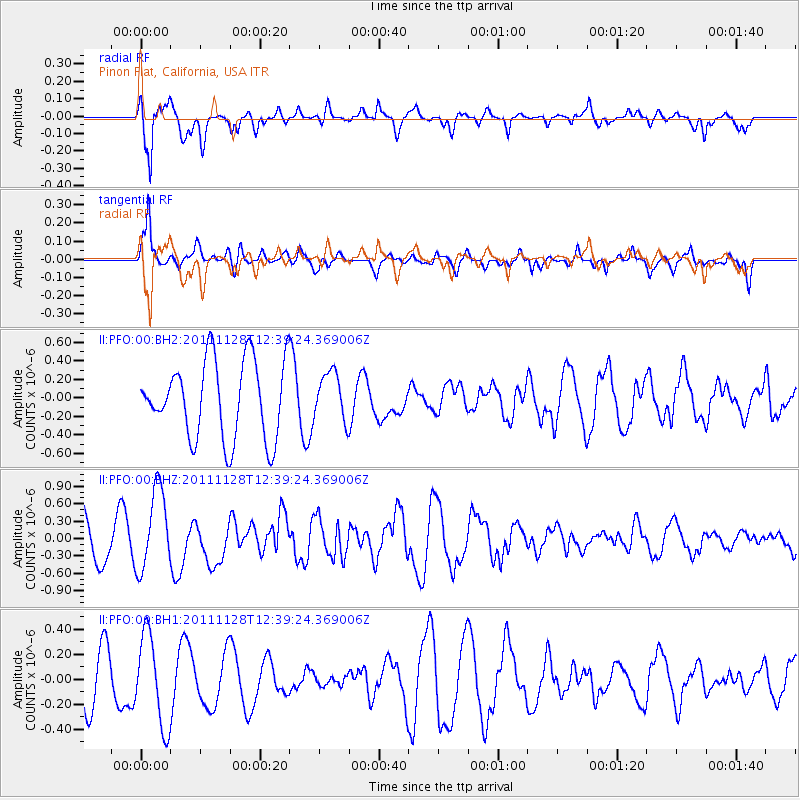
PFO Pinon Flat, California, USA - Earthquake Result Viewer
*The percent match for this event was below the threshold and hence no stack was calculated.
| Earthquake location: |
New Ireland Region, P.N.G. |
| Earthquake latitude/longitude: |
-5.5/153.7 |
| Earthquake time(UTC): |
2011/11/28 (332) 12:26:45 GMT |
| Earthquake Depth: |
25 km |
| Earthquake Magnitude: |
5.9 MB, 6.0 MS, 6.1 MW, 6.2 MW |
| Earthquake Catalog/Contributor: |
WHDF/NEIC |
|
| Network: |
II Global Seismograph Network (GSN - IRIS/IDA) |
| Station: |
PFO Pinon Flat, California, USA |
| Lat/Lon: |
33.61 N/116.46 W |
| Elevation: |
1280 m |
|
| Distance: |
92.8 deg |
| Az: |
56.673 deg |
| Baz: |
265.35 deg |
| Ray Param: |
$rayparam |
*The percent match for this event was below the threshold and hence was not used in the summary stack. |
|
| Radial Match: |
76.68957 % |
| Radial Bump: |
351 |
| Transverse Match: |
78.526764 % |
| Transverse Bump: |
400 |
| SOD ConfigId: |
558545 |
| Insert Time: |
2013-09-19 07:25:52.796 +0000 |
| GWidth: |
2.5 |
| Max Bumps: |
400 |
| Tol: |
0.001 |
|
Signal To Noise
| Channel | StoN | STA | LTA |
| II:PFO:00:BHZ:20111128T12:39:24.369006Z | 1.7871076 | 6.991077E-7 | 3.9119507E-7 |
| II:PFO:00:BH1:20111128T12:39:24.369006Z | 2.0968552 | 3.6475245E-7 | 1.7395213E-7 |
| II:PFO:00:BH2:20111128T12:39:24.369006Z | 0.6229209 | 2.6120594E-7 | 4.1932444E-7 |
| Arrivals |
| Ps | |
| PpPs | |
| PsPs/PpSs | |


