You are here: Home > Network List > YB13 - Continental Dynamics/Cent. Anatolian Tectonics:Surface to Mantle Dynamics During Stations List
> Station AT21 Asiklar,Nevsehir,Turkey > Earthquake Result Viewer
AT21 Asiklar,Nevsehir,Turkey - Earthquake Result Viewer
| Earthquake location: |
Southern Molucca Sea |
| Earthquake latitude/longitude: |
-0.2/125.2 |
| Earthquake time(UTC): |
2014/09/10 (253) 02:46:06 GMT |
| Earthquake Depth: |
30 km |
| Earthquake Magnitude: |
6.2 MWW, 6.1 MWB, 6.5 MI |
| Earthquake Catalog/Contributor: |
NEIC PDE/NEIC COMCAT |
|
| Network: |
YB Continental Dynamics/Cent. Anatolian Tectonics:Surface to Mantle Dynamics During |
| Station: |
AT21 Asiklar,Nevsehir,Turkey |
| Lat/Lon: |
38.93 N/34.52 E |
| Elevation: |
1279 m |
|
| Distance: |
90.6 deg |
| Az: |
308.739 deg |
| Baz: |
89.739 deg |
| Ray Param: |
0.04165686 |
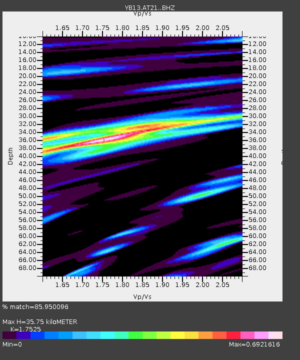
| Estimated Moho Depth: |
35.75 km |
| Estimated Crust Vp/Vs: |
1.75 |
| Assumed Crust Vp: |
6.35 km/s |
| Estimated Crust Vs: |
3.623 km/s |
| Estimated Crust Poisson's Ratio: |
0.26 |
|
| Radial Match: |
85.950096 % |
| Radial Bump: |
400 |
| Transverse Match: |
79.601135 % |
| Transverse Bump: |
400 |
| SOD ConfigId: |
3390531 |
| Insert Time: |
2019-04-13 23:04:51.322 +0000 |
| GWidth: |
2.5 |
| Max Bumps: |
400 |
| Tol: |
0.001 |
|

Signal To Noise
| Channel | StoN | STA | LTA |
| YB:AT21: :BHZ:20140910T02:58:34.72002Z | 21.027235 | 9.921796E-7 | 4.718545E-8 |
| YB:AT21: :BHN:20140910T02:58:34.72002Z | 1.5378615 | 1.04930955E-7 | 6.8231735E-8 |
| YB:AT21: :BHE:20140910T02:58:34.72002Z | 5.548534 | 2.7135243E-7 | 4.890525E-8 |
| Arrivals |
| Ps | 4.3 SECOND |
| PpPs | 15 SECOND |
| PsPs/PpSs | 20 SECOND |


