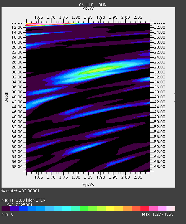
LLLB LILLOOET, BC, CANADA ADA - Earthquake Result Viewer
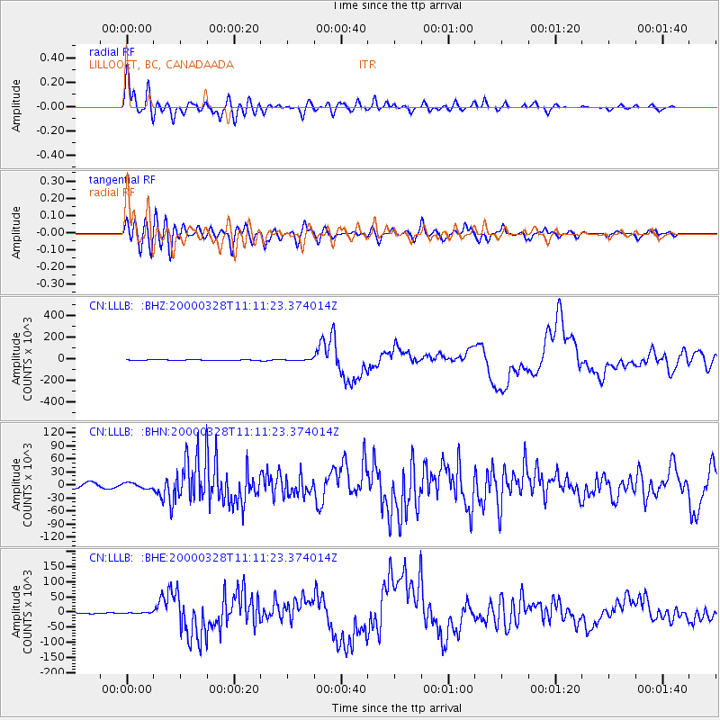
Earthquake location: Volcano Islands, Japan Region
Earthquake latitude/longitude: 22.3/143.7
Earthquake time(UTC): 2000/03/28 (088) 11:00:22 GMT
Earthquake Depth: 126 km
Earthquake Magnitude: 6.8 MB, 7.6 MS, 7.6 MW, 7.6 MW
Earthquake Catalog/Contributor: WHDF/NEIC
Network: CN Canadian National Seismograph Network
Station: LLLB LILLOOET, BC, CANADA ADA
Lat/Lon: 50.61 N/121.88 W
Elevation: 700 m
Distance: 75.8 deg
Az: 40.953 deg
Baz: 287.743 deg
Ray Param: 0.051147036
Estimated Moho Depth: 10.0 km
Estimated Crust Vp/Vs: 1.73
Assumed Crust Vp: 6.597 km/s
Estimated Crust Vs: 3.808 km/s
Estimated Crust Poisson's Ratio: 0.25
Radial Match: 93.38901 %
Radial Bump: 400
Transverse Match: 83.016136 %
Transverse Bump: 400
SOD ConfigId: 3744
Insert Time: 2010-02-27 06:35:18.792 +0000
GWidth: 2.5
Max Bumps: 400
Tol: 0.001

Signal To Noise

ChannelStoNSTALTA
CN:LLLB: :BHN:20000328T11:11:23.374014Z1.01990586110.48835991.2275
CN:LLLB: :BHE:20000328T11:11:23.374014Z0.629063961399.63652224.951
CN:LLLB: :BHZ:20000328T11:11:23.374014Z1.59563116240.24273910.8303
Arrivals
Ps1.1 SECOND
PpPs4.0 SECOND
PsPs/PpSs5.2 SECOND