You are here: Home > Network List > IU - Global Seismograph Network (GSN - IRIS/USGS) Stations List
> Station MAKZ Makanchi, Kazakhstan > Earthquake Result Viewer
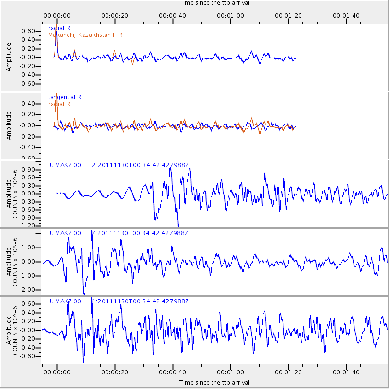
MAKZ Makanchi, Kazakhstan - Earthquake Result Viewer
*The percent match for this event was below the threshold and hence no stack was calculated.
| Earthquake location: |
Philippine Islands Region |
| Earthquake latitude/longitude: |
15.5/119.0 |
| Earthquake time(UTC): |
2011/11/30 (334) 00:27:06 GMT |
| Earthquake Depth: |
9.0 km |
| Earthquake Magnitude: |
6.0 MB, 5.5 MS, 6.0 MW, 6.0 MW |
| Earthquake Catalog/Contributor: |
WHDF/NEIC |
|
| Network: |
IU Global Seismograph Network (GSN - IRIS/USGS) |
| Station: |
MAKZ Makanchi, Kazakhstan |
| Lat/Lon: |
46.81 N/81.98 E |
| Elevation: |
600 m |
|
| Distance: |
43.8 deg |
| Az: |
323.335 deg |
| Baz: |
123.04 deg |
| Ray Param: |
$rayparam |
*The percent match for this event was below the threshold and hence was not used in the summary stack. |
|
| Radial Match: |
79.32464 % |
| Radial Bump: |
304 |
| Transverse Match: |
69.89622 % |
| Transverse Bump: |
400 |
| SOD ConfigId: |
558545 |
| Insert Time: |
2013-09-19 07:32:34.261 +0000 |
| GWidth: |
2.5 |
| Max Bumps: |
400 |
| Tol: |
0.001 |
|
Signal To Noise
| Channel | StoN | STA | LTA |
| IU:MAKZ:00:HHZ:20111130T00:34:42.427988Z | 10.852937 | 7.467265E-7 | 6.8804106E-8 |
| IU:MAKZ:00:HH1:20111130T00:34:42.427988Z | 2.3180537 | 2.1440661E-7 | 9.249424E-8 |
| IU:MAKZ:00:HH2:20111130T00:34:42.427988Z | 4.9701047 | 4.5595831E-7 | 9.174018E-8 |
| Arrivals |
| Ps | |
| PpPs | |
| PsPs/PpSs | |


