You are here: Home > Network List > IU - Global Seismograph Network (GSN - IRIS/USGS) Stations List
> Station PMG Port Moresby, New Guinea > Earthquake Result Viewer
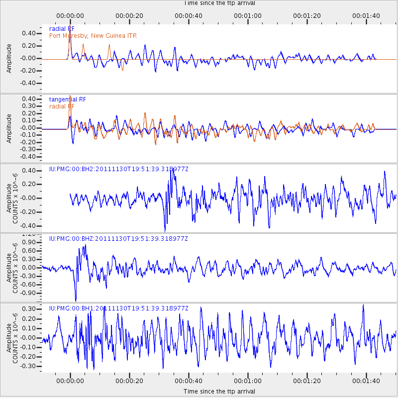
PMG Port Moresby, New Guinea - Earthquake Result Viewer
*The percent match for this event was below the threshold and hence no stack was calculated.
| Earthquake location: |
Nicobar Islands, India Region |
| Earthquake latitude/longitude: |
7.8/93.9 |
| Earthquake time(UTC): |
2011/11/30 (334) 19:42:34 GMT |
| Earthquake Depth: |
17 km |
| Earthquake Magnitude: |
5.5 MB, 5.2 MS, 5.6 MW, 5.5 MW |
| Earthquake Catalog/Contributor: |
WHDF/NEIC |
|
| Network: |
IU Global Seismograph Network (GSN - IRIS/USGS) |
| Station: |
PMG Port Moresby, New Guinea |
| Lat/Lon: |
9.40 S/147.16 E |
| Elevation: |
90 m |
|
| Distance: |
55.8 deg |
| Az: |
106.901 deg |
| Baz: |
286.092 deg |
| Ray Param: |
$rayparam |
*The percent match for this event was below the threshold and hence was not used in the summary stack. |
|
| Radial Match: |
77.92496 % |
| Radial Bump: |
400 |
| Transverse Match: |
66.17577 % |
| Transverse Bump: |
400 |
| SOD ConfigId: |
558545 |
| Insert Time: |
2013-09-19 07:36:55.128 +0000 |
| GWidth: |
2.5 |
| Max Bumps: |
400 |
| Tol: |
0.001 |
|
Signal To Noise
| Channel | StoN | STA | LTA |
| IU:PMG:00:BHZ:20111130T19:51:39.318977Z | 4.3758335 | 4.526895E-7 | 1.0345219E-7 |
| IU:PMG:00:BH1:20111130T19:51:39.318977Z | 1.7811418 | 1.0463059E-7 | 5.874355E-8 |
| IU:PMG:00:BH2:20111130T19:51:39.318977Z | 3.081111 | 1.9935725E-7 | 6.4703045E-8 |
| Arrivals |
| Ps | |
| PpPs | |
| PsPs/PpSs | |


