You are here: Home > Network List > US - United States National Seismic Network Stations List
> Station EGMT Eagleton, Montana, USA > Earthquake Result Viewer
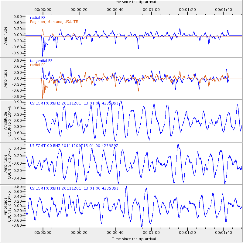
EGMT Eagleton, Montana, USA - Earthquake Result Viewer
*The percent match for this event was below the threshold and hence no stack was calculated.
| Earthquake location: |
Southern Xinjiang, China |
| Earthquake latitude/longitude: |
38.3/76.9 |
| Earthquake time(UTC): |
2011/12/01 (335) 12:48:17 GMT |
| Earthquake Depth: |
32 km |
| Earthquake Magnitude: |
5.6 ML |
| Earthquake Catalog/Contributor: |
NEIC PDE/NEIC PDE-W |
|
| Network: |
US United States National Seismic Network |
| Station: |
EGMT Eagleton, Montana, USA |
| Lat/Lon: |
48.02 N/109.75 W |
| Elevation: |
1055 m |
|
| Distance: |
93.8 deg |
| Az: |
4.464 deg |
| Baz: |
354.767 deg |
| Ray Param: |
$rayparam |
*The percent match for this event was below the threshold and hence was not used in the summary stack. |
|
| Radial Match: |
63.738697 % |
| Radial Bump: |
400 |
| Transverse Match: |
57.251976 % |
| Transverse Bump: |
400 |
| SOD ConfigId: |
558545 |
| Insert Time: |
2013-09-19 07:39:18.433 +0000 |
| GWidth: |
2.5 |
| Max Bumps: |
400 |
| Tol: |
0.001 |
|
Signal To Noise
| Channel | StoN | STA | LTA |
| US:EGMT:00:BHZ:20111201T13:01:00.423989Z | 0.56772417 | 1.0982399E-7 | 1.9344604E-7 |
| US:EGMT:00:BH1:20111201T13:01:00.423989Z | 0.48228267 | 2.3822335E-7 | 4.9394964E-7 |
| US:EGMT:00:BH2:20111201T13:01:00.423989Z | 1.7005402 | 5.5582325E-7 | 3.26851E-7 |
| Arrivals |
| Ps | |
| PpPs | |
| PsPs/PpSs | |


