You are here: Home > Network List > CN - Canadian National Seismograph Network Stations List
> Station LLLB LILLOOET, BC, CANADA ADA > Earthquake Result Viewer
LLLB LILLOOET, BC, CANADA ADA - Earthquake Result Viewer
| Earthquake location: |
Fiji Islands Region |
| Earthquake latitude/longitude: |
-21.4/-176.5 |
| Earthquake time(UTC): |
1999/04/13 (103) 10:38:48 GMT |
| Earthquake Depth: |
164 km |
| Earthquake Magnitude: |
6.4 MB, 6.8 MW, 6.8 MW |
| Earthquake Catalog/Contributor: |
WHDF/NEIC |
|
| Network: |
CN Canadian National Seismograph Network |
| Station: |
LLLB LILLOOET, BC, CANADA ADA |
| Lat/Lon: |
50.61 N/121.88 W |
| Elevation: |
700 m |
|
| Distance: |
86.3 deg |
| Az: |
31.352 deg |
| Baz: |
229.54 deg |
| Ray Param: |
0.043761566 |
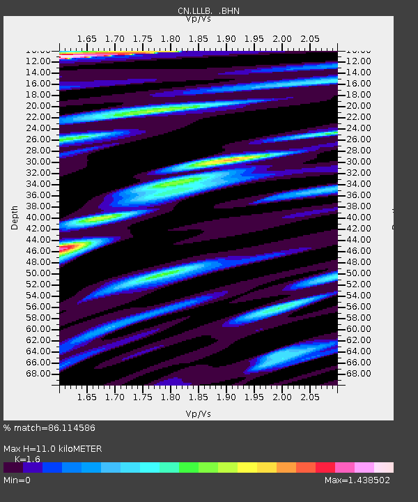
| Estimated Moho Depth: |
11.0 km |
| Estimated Crust Vp/Vs: |
1.60 |
| Assumed Crust Vp: |
6.597 km/s |
| Estimated Crust Vs: |
4.123 km/s |
| Estimated Crust Poisson's Ratio: |
0.18 |
|
| Radial Match: |
86.114586 % |
| Radial Bump: |
400 |
| Transverse Match: |
84.72408 % |
| Transverse Bump: |
400 |
| SOD ConfigId: |
4480 |
| Insert Time: |
2010-02-27 06:35:26.690 +0000 |
| GWidth: |
2.5 |
| Max Bumps: |
400 |
| Tol: |
0.001 |
|
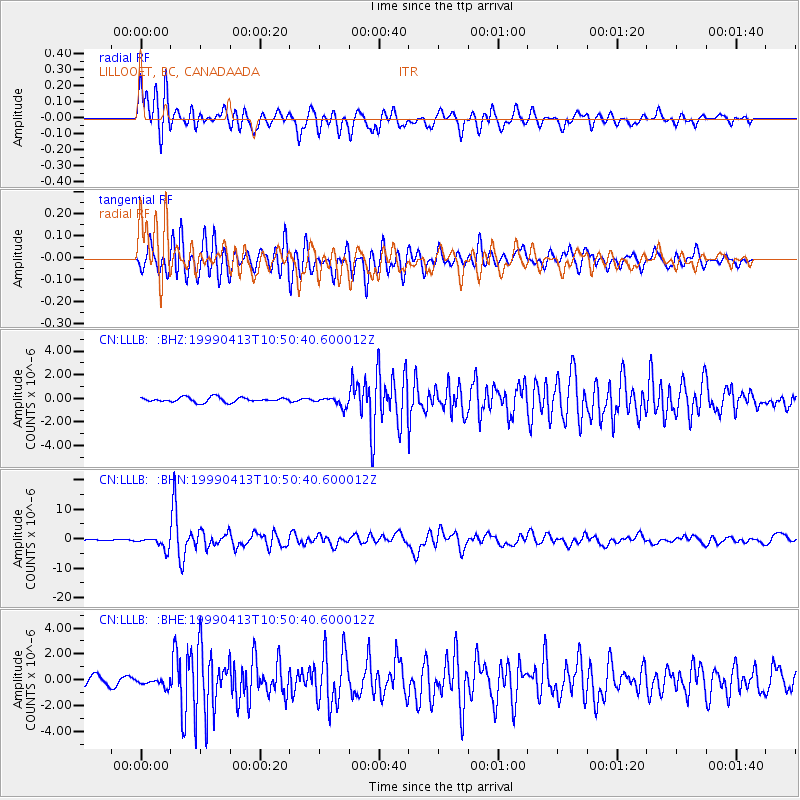
Signal To Noise
| Channel | StoN | STA | LTA |
| CN:LLLB: :BHN:19990413T10:50:40.600012Z | 14.257852 | 2.0426303E-6 | 1.4326355E-7 |
| CN:LLLB: :BHE:19990413T10:50:40.600012Z | 1.0775366 | 3.098067E-7 | 2.8751384E-7 |
| CN:LLLB: :BHZ:19990413T10:50:40.600012Z | 2.0923958 | 4.1743064E-7 | 1.9949888E-7 |
| Arrivals |
| Ps | 1.0 SECOND |
| PpPs | 4.2 SECOND |
| PsPs/PpSs | 5.2 SECOND |


