You are here: Home > Network List > IU - Global Seismograph Network (GSN - IRIS/USGS) Stations List
> Station KMBO Kilima Mbogo, Kenya > Earthquake Result Viewer
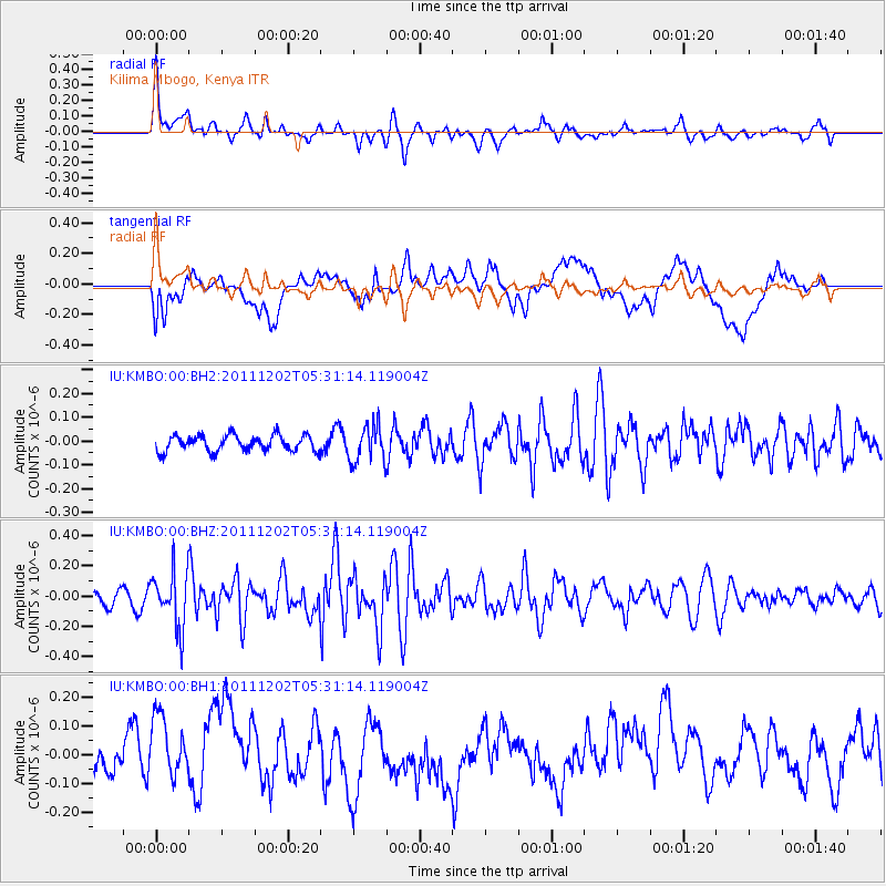
KMBO Kilima Mbogo, Kenya - Earthquake Result Viewer
*The percent match for this event was below the threshold and hence no stack was calculated.
| Earthquake location: |
Minahassa Peninsula, Sulawesi |
| Earthquake latitude/longitude: |
0.1/120.5 |
| Earthquake time(UTC): |
2011/12/02 (336) 05:19:26 GMT |
| Earthquake Depth: |
75 km |
| Earthquake Magnitude: |
5.5 MW, 5.5 MW, 5.9 MB |
| Earthquake Catalog/Contributor: |
NEIC PDE/NEIC PDE-W |
|
| Network: |
IU Global Seismograph Network (GSN - IRIS/USGS) |
| Station: |
KMBO Kilima Mbogo, Kenya |
| Lat/Lon: |
1.13 S/37.25 E |
| Elevation: |
1950 m |
|
| Distance: |
83.3 deg |
| Az: |
268.858 deg |
| Baz: |
89.746 deg |
| Ray Param: |
$rayparam |
*The percent match for this event was below the threshold and hence was not used in the summary stack. |
|
| Radial Match: |
72.49855 % |
| Radial Bump: |
387 |
| Transverse Match: |
30.337988 % |
| Transverse Bump: |
400 |
| SOD ConfigId: |
558545 |
| Insert Time: |
2013-09-19 07:42:33.139 +0000 |
| GWidth: |
2.5 |
| Max Bumps: |
400 |
| Tol: |
0.001 |
|
Signal To Noise
| Channel | StoN | STA | LTA |
| IU:KMBO:00:BHZ:20111202T05:31:14.119004Z | 3.8376324 | 1.8546376E-7 | 4.832765E-8 |
| IU:KMBO:00:BH1:20111202T05:31:14.119004Z | 1.2916157 | 1.6162453E-7 | 1.2513361E-7 |
| IU:KMBO:00:BH2:20111202T05:31:14.119004Z | 2.3430152 | 7.849853E-8 | 3.3503213E-8 |
| Arrivals |
| Ps | |
| PpPs | |
| PsPs/PpSs | |


