You are here: Home > Network List > CN - Canadian National Seismograph Network Stations List
> Station LLLB LILLOOET, BC, CANADA ADA > Earthquake Result Viewer
LLLB LILLOOET, BC, CANADA ADA - Earthquake Result Viewer
| Earthquake location: |
Near Coast Of Chiapas, Mexico |
| Earthquake latitude/longitude: |
15.6/-93.1 |
| Earthquake time(UTC): |
2001/11/28 (332) 14:32:32 GMT |
| Earthquake Depth: |
85 km |
| Earthquake Magnitude: |
5.7 MB, 6.4 MW, 6.4 MW |
| Earthquake Catalog/Contributor: |
WHDF/NEIC |
|
| Network: |
CN Canadian National Seismograph Network |
| Station: |
LLLB LILLOOET, BC, CANADA ADA |
| Lat/Lon: |
50.61 N/121.88 W |
| Elevation: |
700 m |
|
| Distance: |
41.9 deg |
| Az: |
332.684 deg |
| Baz: |
136.041 deg |
| Ray Param: |
0.0732015 |
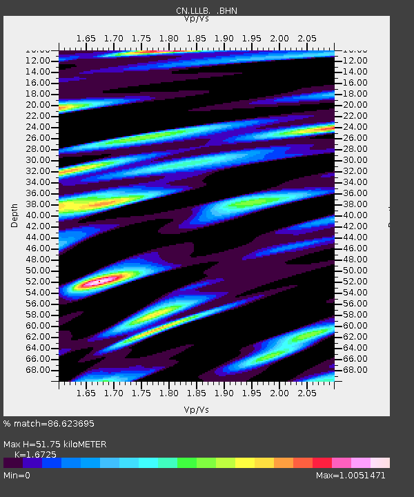
| Estimated Moho Depth: |
51.75 km |
| Estimated Crust Vp/Vs: |
1.67 |
| Assumed Crust Vp: |
6.597 km/s |
| Estimated Crust Vs: |
3.945 km/s |
| Estimated Crust Poisson's Ratio: |
0.22 |
|
| Radial Match: |
86.623695 % |
| Radial Bump: |
400 |
| Transverse Match: |
72.863464 % |
| Transverse Bump: |
400 |
| SOD ConfigId: |
20082 |
| Insert Time: |
2010-02-27 06:35:28.962 +0000 |
| GWidth: |
2.5 |
| Max Bumps: |
400 |
| Tol: |
0.001 |
|
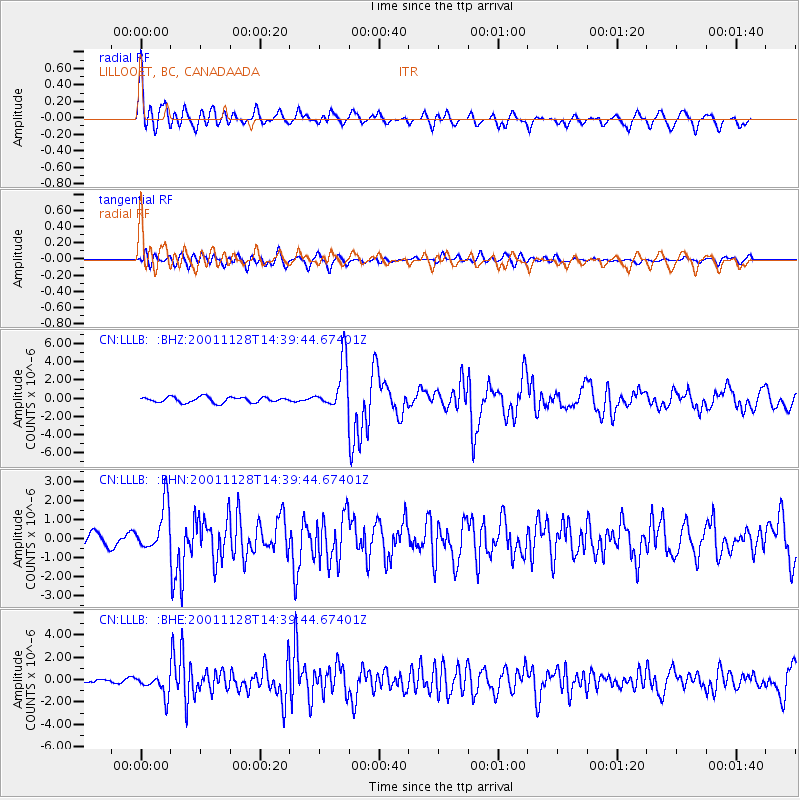
Signal To Noise
| Channel | StoN | STA | LTA |
| CN:LLLB: :BHN:20011128T14:39:44.67401Z | 5.421296 | 1.2116524E-6 | 2.2349866E-7 |
| CN:LLLB: :BHE:20011128T14:39:44.67401Z | 3.721691 | 9.274767E-7 | 2.4920843E-7 |
| CN:LLLB: :BHZ:20011128T14:39:44.67401Z | 8.863824 | 2.6567438E-6 | 2.9972884E-7 |
| Arrivals |
| Ps | 5.7 SECOND |
| PpPs | 19 SECOND |
| PsPs/PpSs | 25 SECOND |


