You are here: Home > Network List > US - United States National Seismic Network Stations List
> Station AMTX Amarillo, Texas, USA > Earthquake Result Viewer
AMTX Amarillo, Texas, USA - Earthquake Result Viewer
*The percent match for this event was below the threshold and hence no stack was calculated.
| Earthquake location: |
Leeward Islands |
| Earthquake latitude/longitude: |
18.0/-59.8 |
| Earthquake time(UTC): |
2011/12/03 (337) 09:27:11 GMT |
| Earthquake Depth: |
10 km |
| Earthquake Magnitude: |
5.6 MW, 5.2 MS, 5.4 MB, 5.6 MW |
| Earthquake Catalog/Contributor: |
WHDF/NEIC |
|
| Network: |
US United States National Seismic Network |
| Station: |
AMTX Amarillo, Texas, USA |
| Lat/Lon: |
34.53 N/101.41 W |
| Elevation: |
1010 m |
|
| Distance: |
40.5 deg |
| Az: |
302.409 deg |
| Baz: |
103.239 deg |
| Ray Param: |
$rayparam |
*The percent match for this event was below the threshold and hence was not used in the summary stack. |
|
| Radial Match: |
51.054726 % |
| Radial Bump: |
400 |
| Transverse Match: |
46.711384 % |
| Transverse Bump: |
400 |
| SOD ConfigId: |
558545 |
| Insert Time: |
2013-09-19 07:46:09.862 +0000 |
| GWidth: |
2.5 |
| Max Bumps: |
400 |
| Tol: |
0.001 |
|
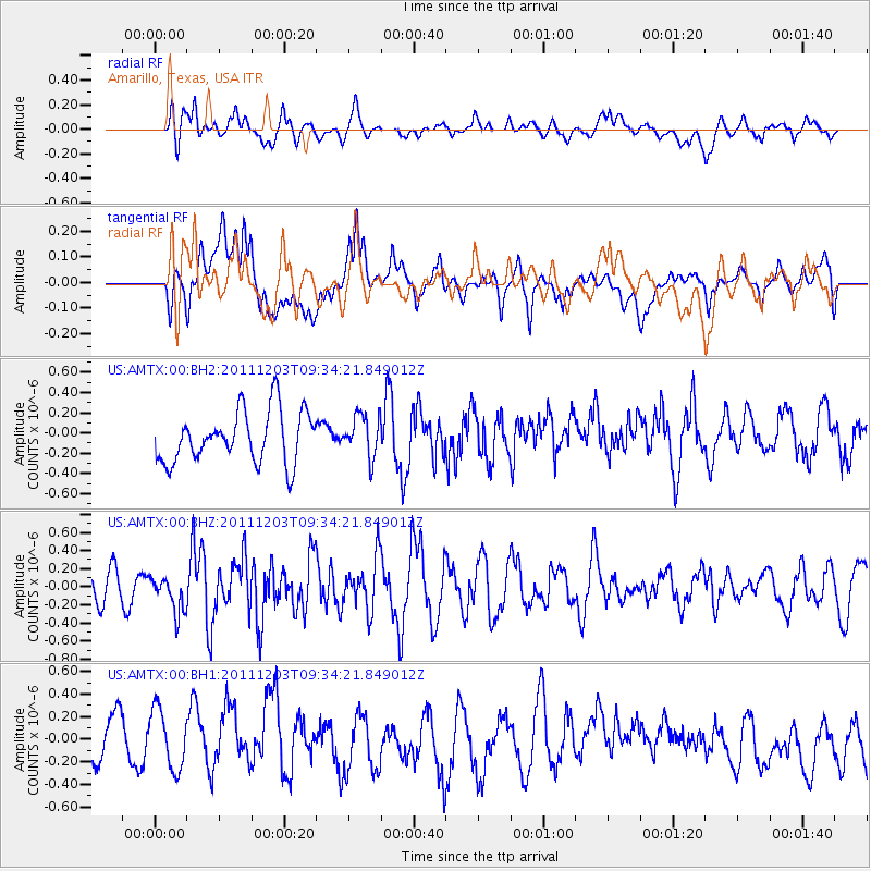
Signal To Noise
| Channel | StoN | STA | LTA |
| US:AMTX:00:BHZ:20111203T09:34:21.849012Z | 1.1254938 | 2.0617719E-7 | 1.831882E-7 |
| US:AMTX:00:BH1:20111203T09:34:21.849012Z | 1.4566551 | 2.6134467E-7 | 1.7941422E-7 |
| US:AMTX:00:BH2:20111203T09:34:21.849012Z | 0.6352447 | 1.5980328E-7 | 2.5156174E-7 |
| Arrivals |
| Ps | |
| PpPs | |
| PsPs/PpSs | |


