You are here: Home > Network List > CN - Canadian National Seismograph Network Stations List
> Station LLLB LILLOOET, BC, CANADA ADA > Earthquake Result Viewer
LLLB LILLOOET, BC, CANADA ADA - Earthquake Result Viewer
| Earthquake location: |
El Salvador |
| Earthquake latitude/longitude: |
13.0/-88.7 |
| Earthquake time(UTC): |
2001/01/13 (013) 17:33:32 GMT |
| Earthquake Depth: |
60 km |
| Earthquake Magnitude: |
6.4 MB, 7.8 MS, 7.7 MW, 7.5 ME |
| Earthquake Catalog/Contributor: |
WHDF/NEIC |
|
| Network: |
CN Canadian National Seismograph Network |
| Station: |
LLLB LILLOOET, BC, CANADA ADA |
| Lat/Lon: |
50.61 N/121.88 W |
| Elevation: |
700 m |
|
| Distance: |
46.2 deg |
| Az: |
331.067 deg |
| Baz: |
132.274 deg |
| Ray Param: |
0.070634805 |
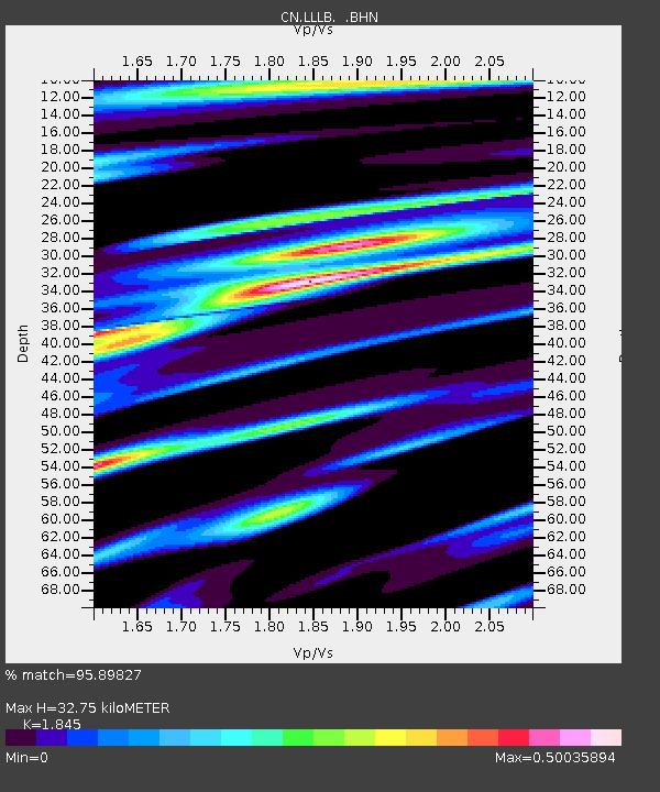
| Estimated Moho Depth: |
32.75 km |
| Estimated Crust Vp/Vs: |
1.85 |
| Assumed Crust Vp: |
6.597 km/s |
| Estimated Crust Vs: |
3.576 km/s |
| Estimated Crust Poisson's Ratio: |
0.29 |
|
| Radial Match: |
95.89827 % |
| Radial Bump: |
400 |
| Transverse Match: |
90.07974 % |
| Transverse Bump: |
400 |
| SOD ConfigId: |
3744 |
| Insert Time: |
2010-02-27 06:35:42.381 +0000 |
| GWidth: |
2.5 |
| Max Bumps: |
400 |
| Tol: |
0.001 |
|
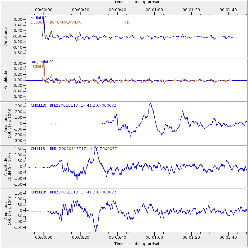
Signal To Noise
| Channel | StoN | STA | LTA |
| CN:LLLB: :BHN:20010113T17:41:20.700007Z | 2.3445394 | 8267.795 | 3526.4048 |
| CN:LLLB: :BHE:20010113T17:41:20.700007Z | 4.284503 | 9628.823 | 2247.3606 |
| CN:LLLB: :BHZ:20010113T17:41:20.700007Z | 12.241817 | 22335.615 | 1824.5342 |
| Arrivals |
| Ps | 4.5 SECOND |
| PpPs | 13 SECOND |
| PsPs/PpSs | 18 SECOND |


