You are here: Home > Network List > IU - Global Seismograph Network (GSN - IRIS/USGS) Stations List
> Station KIP Kipapa, Hawaii, USA > Earthquake Result Viewer
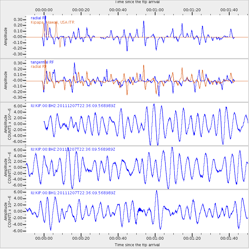
KIP Kipapa, Hawaii, USA - Earthquake Result Viewer
*The percent match for this event was below the threshold and hence no stack was calculated.
| Earthquake location: |
Near Coast Of Northern Chile |
| Earthquake latitude/longitude: |
-27.9/-70.9 |
| Earthquake time(UTC): |
2011/12/07 (341) 22:23:09 GMT |
| Earthquake Depth: |
20 km |
| Earthquake Magnitude: |
5.8 MB, 5.8 MS, 6.1 MW, 6.0 MW |
| Earthquake Catalog/Contributor: |
WHDF/NEIC |
|
| Network: |
IU Global Seismograph Network (GSN - IRIS/USGS) |
| Station: |
KIP Kipapa, Hawaii, USA |
| Lat/Lon: |
21.42 N/158.01 W |
| Elevation: |
110 m |
|
| Distance: |
97.3 deg |
| Az: |
290.252 deg |
| Baz: |
116.98 deg |
| Ray Param: |
$rayparam |
*The percent match for this event was below the threshold and hence was not used in the summary stack. |
|
| Radial Match: |
46.798275 % |
| Radial Bump: |
342 |
| Transverse Match: |
48.213417 % |
| Transverse Bump: |
288 |
| SOD ConfigId: |
558545 |
| Insert Time: |
2013-09-19 07:53:19.495 +0000 |
| GWidth: |
2.5 |
| Max Bumps: |
400 |
| Tol: |
0.001 |
|
Signal To Noise
| Channel | StoN | STA | LTA |
| IU:KIP:00:BHZ:20111207T22:36:09.568989Z | 0.88729626 | 2.1044323E-6 | 2.3717357E-6 |
| IU:KIP:00:BH1:20111207T22:36:09.568989Z | 2.0852363 | 3.1215907E-6 | 1.4969962E-6 |
| IU:KIP:00:BH2:20111207T22:36:09.568989Z | 1.2825383 | 2.2483348E-6 | 1.7530353E-6 |
| Arrivals |
| Ps | |
| PpPs | |
| PsPs/PpSs | |


