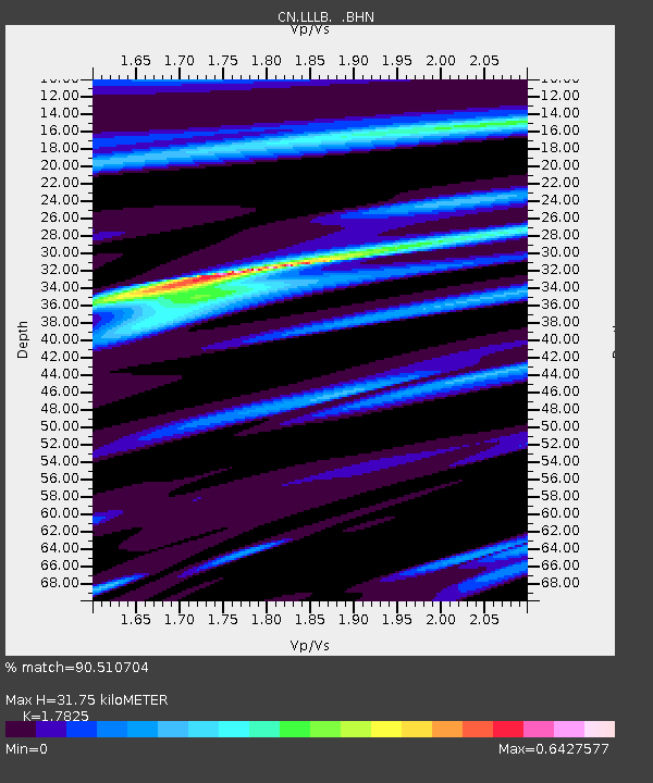
LLLB LILLOOET, BC, CANADA ADA - Earthquake Result Viewer
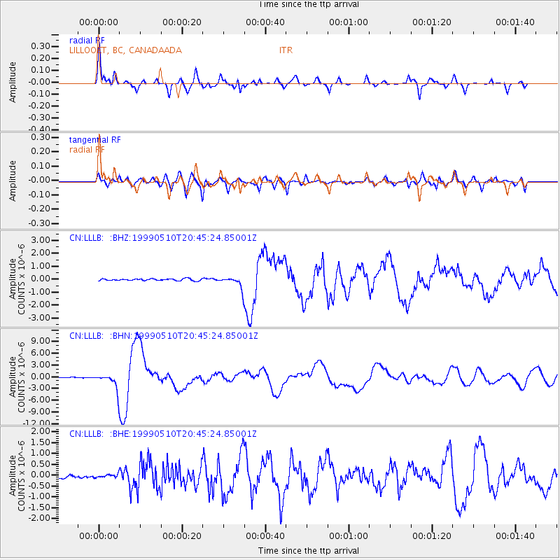
Earthquake location: New Britain Region, P.N.G.
Earthquake latitude/longitude: -5.2/150.9
Earthquake time(UTC): 1999/05/10 (130) 20:33:02 GMT
Earthquake Depth: 138 km
Earthquake Magnitude: 6.5 MB, 6.8 MS, 7.1 MW, 6.5 MB
Earthquake Catalog/Contributor: WHDF/NEIC
Network: CN Canadian National Seismograph Network
Station: LLLB LILLOOET, BC, CANADA ADA
Lat/Lon: 50.61 N/121.88 W
Elevation: 700 m
Distance: 92.2 deg
Az: 39.56 deg
Baz: 264.608 deg
Ray Param: 0.04142821
Estimated Moho Depth: 31.75 km
Estimated Crust Vp/Vs: 1.78
Assumed Crust Vp: 6.597 km/s
Estimated Crust Vs: 3.701 km/s
Estimated Crust Poisson's Ratio: 0.27
Radial Match: 90.510704 %
Radial Bump: 356
Transverse Match: 77.14866 %
Transverse Bump: 400
SOD ConfigId: 4480
Insert Time: 2010-02-27 06:36:19.668 +0000
GWidth: 2.5
Max Bumps: 400
Tol: 0.001

Signal To Noise

ChannelStoNSTALTA
CN:LLLB: :BHN:19990510T20:45:24.85001Z27.2781982.0848452E-67.642899E-8
CN:LLLB: :BHE:19990510T20:45:24.85001Z1.15046537.722328E-86.712352E-8
CN:LLLB: :BHZ:19990510T20:45:24.85001Z7.0635484.9226975E-76.9691566E-8
Arrivals
Ps3.8 SECOND
PpPs13 SECOND
PsPs/PpSs17 SECOND