You are here: Home > Network List > IU - Global Seismograph Network (GSN - IRIS/USGS) Stations List
> Station HNR Honiara, Solomon Islands > Earthquake Result Viewer
HNR Honiara, Solomon Islands - Earthquake Result Viewer
*The percent match for this event was below the threshold and hence no stack was calculated.
| Earthquake location: |
Sea Of Okhotsk |
| Earthquake latitude/longitude: |
47.0/144.6 |
| Earthquake time(UTC): |
2011/12/09 (343) 19:42:57 GMT |
| Earthquake Depth: |
392 km |
| Earthquake Magnitude: |
5.7 MB, 5.7 MW, 5.8 MW |
| Earthquake Catalog/Contributor: |
WHDF/NEIC |
|
| Network: |
IU Global Seismograph Network (GSN - IRIS/USGS) |
| Station: |
HNR Honiara, Solomon Islands |
| Lat/Lon: |
9.44 S/159.95 E |
| Elevation: |
100 m |
|
| Distance: |
57.8 deg |
| Az: |
161.977 deg |
| Baz: |
347.608 deg |
| Ray Param: |
$rayparam |
*The percent match for this event was below the threshold and hence was not used in the summary stack. |
|
| Radial Match: |
62.070614 % |
| Radial Bump: |
400 |
| Transverse Match: |
54.6287 % |
| Transverse Bump: |
400 |
| SOD ConfigId: |
558545 |
| Insert Time: |
2013-09-19 07:59:15.807 +0000 |
| GWidth: |
2.5 |
| Max Bumps: |
400 |
| Tol: |
0.001 |
|
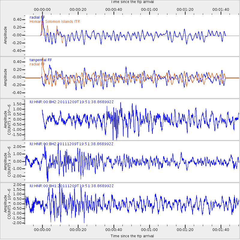
Signal To Noise
| Channel | StoN | STA | LTA |
| IU:HNR:00:BHZ:20111209T19:51:38.868992Z | 2.7784984 | 1.0899953E-6 | 3.9229656E-7 |
| IU:HNR:00:BH1:20111209T19:51:38.868992Z | 1.722967 | 7.080758E-7 | 4.1096305E-7 |
| IU:HNR:00:BH2:20111209T19:51:38.868992Z | 1.147246 | 3.9817624E-7 | 3.4707136E-7 |
| Arrivals |
| Ps | |
| PpPs | |
| PsPs/PpSs | |


