You are here: Home > Network List > IU - Global Seismograph Network (GSN - IRIS/USGS) Stations List
> Station JOHN Johnston Island, USA > Earthquake Result Viewer
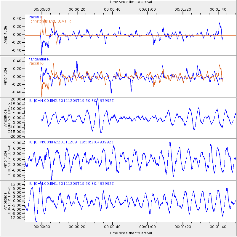
JOHN Johnston Island, USA - Earthquake Result Viewer
*The percent match for this event was below the threshold and hence no stack was calculated.
| Earthquake location: |
Sea Of Okhotsk |
| Earthquake latitude/longitude: |
47.0/144.6 |
| Earthquake time(UTC): |
2011/12/09 (343) 19:42:57 GMT |
| Earthquake Depth: |
392 km |
| Earthquake Magnitude: |
5.7 MB, 5.7 MW, 5.8 MW |
| Earthquake Catalog/Contributor: |
WHDF/NEIC |
|
| Network: |
IU Global Seismograph Network (GSN - IRIS/USGS) |
| Station: |
JOHN Johnston Island, USA |
| Lat/Lon: |
16.73 N/169.53 W |
| Elevation: |
2.0 m |
|
| Distance: |
48.3 deg |
| Az: |
112.863 deg |
| Baz: |
318.846 deg |
| Ray Param: |
$rayparam |
*The percent match for this event was below the threshold and hence was not used in the summary stack. |
|
| Radial Match: |
37.583473 % |
| Radial Bump: |
400 |
| Transverse Match: |
51.738075 % |
| Transverse Bump: |
395 |
| SOD ConfigId: |
558545 |
| Insert Time: |
2013-09-19 07:59:16.718 +0000 |
| GWidth: |
2.5 |
| Max Bumps: |
400 |
| Tol: |
0.001 |
|
Signal To Noise
| Channel | StoN | STA | LTA |
| IU:JOHN:00:BHZ:20111209T19:50:30.493992Z | 0.9889615 | 3.091407E-6 | 3.1259124E-6 |
| IU:JOHN:00:BH1:20111209T19:50:30.493992Z | 1.6794838 | 6.6214884E-6 | 3.9425736E-6 |
| IU:JOHN:00:BH2:20111209T19:50:30.493992Z | 3.5069647 | 1.2382261E-5 | 3.530763E-6 |
| Arrivals |
| Ps | |
| PpPs | |
| PsPs/PpSs | |


