You are here: Home > Network List > US - United States National Seismic Network Stations List
> Station DGMT Dagmar, Montana, USA > Earthquake Result Viewer
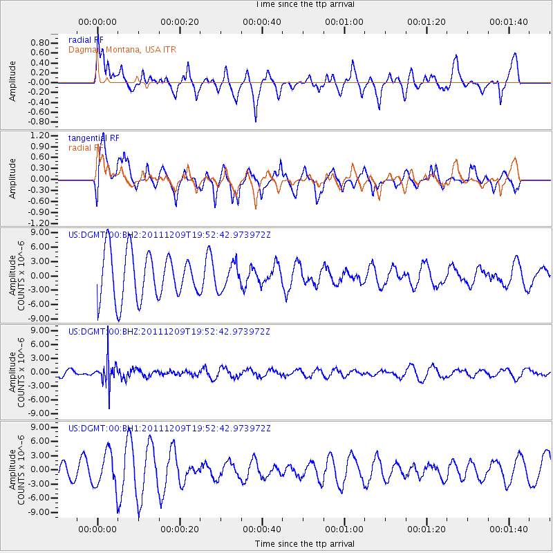
DGMT Dagmar, Montana, USA - Earthquake Result Viewer
*The percent match for this event was below the threshold and hence no stack was calculated.
| Earthquake location: |
Sea Of Okhotsk |
| Earthquake latitude/longitude: |
47.0/144.6 |
| Earthquake time(UTC): |
2011/12/09 (343) 19:42:57 GMT |
| Earthquake Depth: |
392 km |
| Earthquake Magnitude: |
5.7 MB, 5.7 MW, 5.8 MW |
| Earthquake Catalog/Contributor: |
WHDF/NEIC |
|
| Network: |
US United States National Seismic Network |
| Station: |
DGMT Dagmar, Montana, USA |
| Lat/Lon: |
48.47 N/104.20 W |
| Elevation: |
0.0 m |
|
| Distance: |
67.7 deg |
| Az: |
42.089 deg |
| Baz: |
316.429 deg |
| Ray Param: |
$rayparam |
*The percent match for this event was below the threshold and hence was not used in the summary stack. |
|
| Radial Match: |
45.068626 % |
| Radial Bump: |
400 |
| Transverse Match: |
61.003418 % |
| Transverse Bump: |
400 |
| SOD ConfigId: |
558545 |
| Insert Time: |
2013-09-19 08:00:39.852 +0000 |
| GWidth: |
2.5 |
| Max Bumps: |
400 |
| Tol: |
0.001 |
|
Signal To Noise
| Channel | StoN | STA | LTA |
| US:DGMT:00:BHZ:20111209T19:52:42.973972Z | 3.0269842 | 2.6300547E-6 | 8.688697E-7 |
| US:DGMT:00:BH1:20111209T19:52:42.973972Z | 2.5164473 | 3.894539E-6 | 1.5476339E-6 |
| US:DGMT:00:BH2:20111209T19:52:42.973972Z | 0.55118155 | 2.6898767E-6 | 4.880201E-6 |
| Arrivals |
| Ps | |
| PpPs | |
| PsPs/PpSs | |


