You are here: Home > Network List > US - United States National Seismic Network Stations List
> Station TPNV Topopah Spring, Nevada, USA > Earthquake Result Viewer
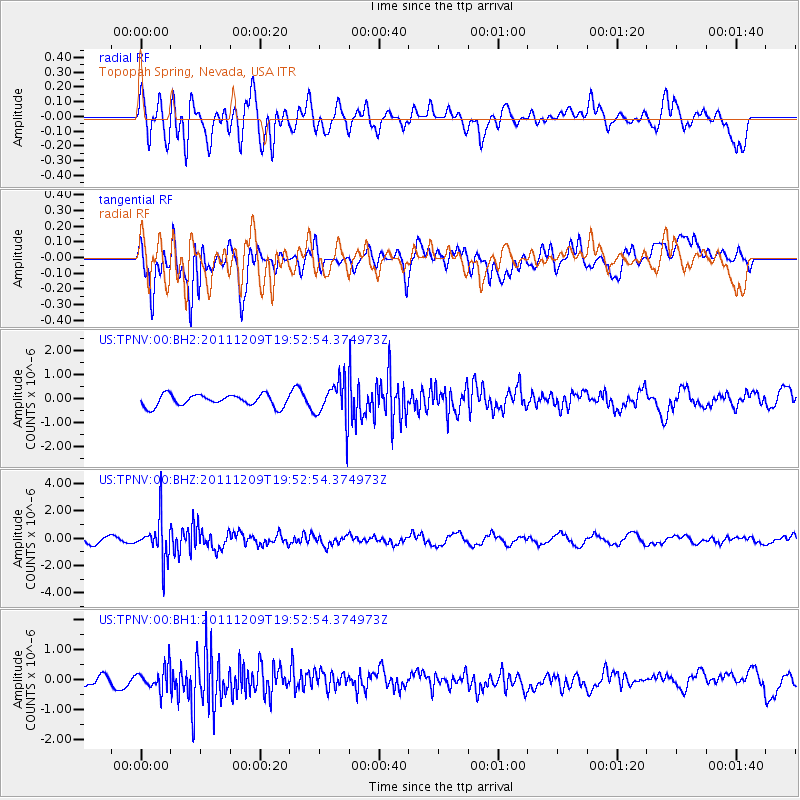
TPNV Topopah Spring, Nevada, USA - Earthquake Result Viewer
*The percent match for this event was below the threshold and hence no stack was calculated.
| Earthquake location: |
Sea Of Okhotsk |
| Earthquake latitude/longitude: |
47.0/144.6 |
| Earthquake time(UTC): |
2011/12/09 (343) 19:42:57 GMT |
| Earthquake Depth: |
392 km |
| Earthquake Magnitude: |
5.7 MB, 5.7 MW, 5.8 MW |
| Earthquake Catalog/Contributor: |
WHDF/NEIC |
|
| Network: |
US United States National Seismic Network |
| Station: |
TPNV Topopah Spring, Nevada, USA |
| Lat/Lon: |
36.95 N/116.25 W |
| Elevation: |
1600 m |
|
| Distance: |
69.6 deg |
| Az: |
57.542 deg |
| Baz: |
313.88 deg |
| Ray Param: |
$rayparam |
*The percent match for this event was below the threshold and hence was not used in the summary stack. |
|
| Radial Match: |
51.799763 % |
| Radial Bump: |
400 |
| Transverse Match: |
67.6878 % |
| Transverse Bump: |
400 |
| SOD ConfigId: |
558545 |
| Insert Time: |
2013-09-19 08:01:47.435 +0000 |
| GWidth: |
2.5 |
| Max Bumps: |
400 |
| Tol: |
0.001 |
|
Signal To Noise
| Channel | StoN | STA | LTA |
| US:TPNV:00:BHZ:20111209T19:52:54.374973Z | 3.5729117 | 1.5095301E-6 | 4.2249297E-7 |
| US:TPNV:00:BH1:20111209T19:52:54.374973Z | 1.0213703 | 3.9231335E-7 | 3.8410494E-7 |
| US:TPNV:00:BH2:20111209T19:52:54.374973Z | 3.4816387 | 8.418804E-7 | 2.418058E-7 |
| Arrivals |
| Ps | |
| PpPs | |
| PsPs/PpSs | |


