You are here: Home > Network List > CU - Caribbean Network (USGS) Stations List
> Station BBGH Gun Hill, Barbados > Earthquake Result Viewer
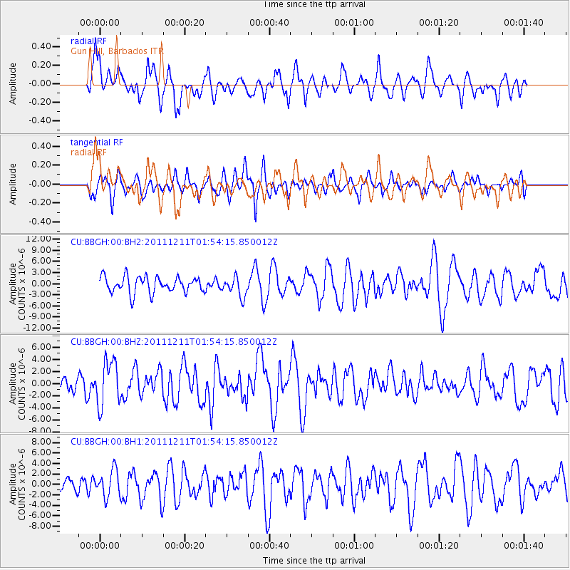
BBGH Gun Hill, Barbados - Earthquake Result Viewer
*The percent match for this event was below the threshold and hence no stack was calculated.
| Earthquake location: |
Guerrero, Mexico |
| Earthquake latitude/longitude: |
17.8/-100.0 |
| Earthquake time(UTC): |
2011/12/11 (345) 01:47:25 GMT |
| Earthquake Depth: |
54 km |
| Earthquake Magnitude: |
6.2 MB, 6.5 MW, 6.5 MW |
| Earthquake Catalog/Contributor: |
WHDF/NEIC |
|
| Network: |
CU Caribbean Network (USGS) |
| Station: |
BBGH Gun Hill, Barbados |
| Lat/Lon: |
13.14 N/59.56 W |
| Elevation: |
180 m |
|
| Distance: |
39.2 deg |
| Az: |
90.972 deg |
| Baz: |
282.14 deg |
| Ray Param: |
$rayparam |
*The percent match for this event was below the threshold and hence was not used in the summary stack. |
|
| Radial Match: |
61.946186 % |
| Radial Bump: |
400 |
| Transverse Match: |
55.735462 % |
| Transverse Bump: |
397 |
| SOD ConfigId: |
558545 |
| Insert Time: |
2013-09-19 08:07:35.582 +0000 |
| GWidth: |
2.5 |
| Max Bumps: |
400 |
| Tol: |
0.001 |
|
Signal To Noise
| Channel | StoN | STA | LTA |
| CU:BBGH:00:BHZ:20111211T01:54:15.850012Z | 3.5944595 | 3.7812865E-6 | 1.0519765E-6 |
| CU:BBGH:00:BH1:20111211T01:54:15.850012Z | 1.534192 | 2.6040077E-6 | 1.6973155E-6 |
| CU:BBGH:00:BH2:20111211T01:54:15.850012Z | 1.7883861 | 3.6812694E-6 | 2.058431E-6 |
| Arrivals |
| Ps | |
| PpPs | |
| PsPs/PpSs | |


