You are here: Home > Network List > CN - Canadian National Seismograph Network Stations List
> Station LLLB LILLOOET, BC, CANADA ADA > Earthquake Result Viewer
LLLB LILLOOET, BC, CANADA ADA - Earthquake Result Viewer
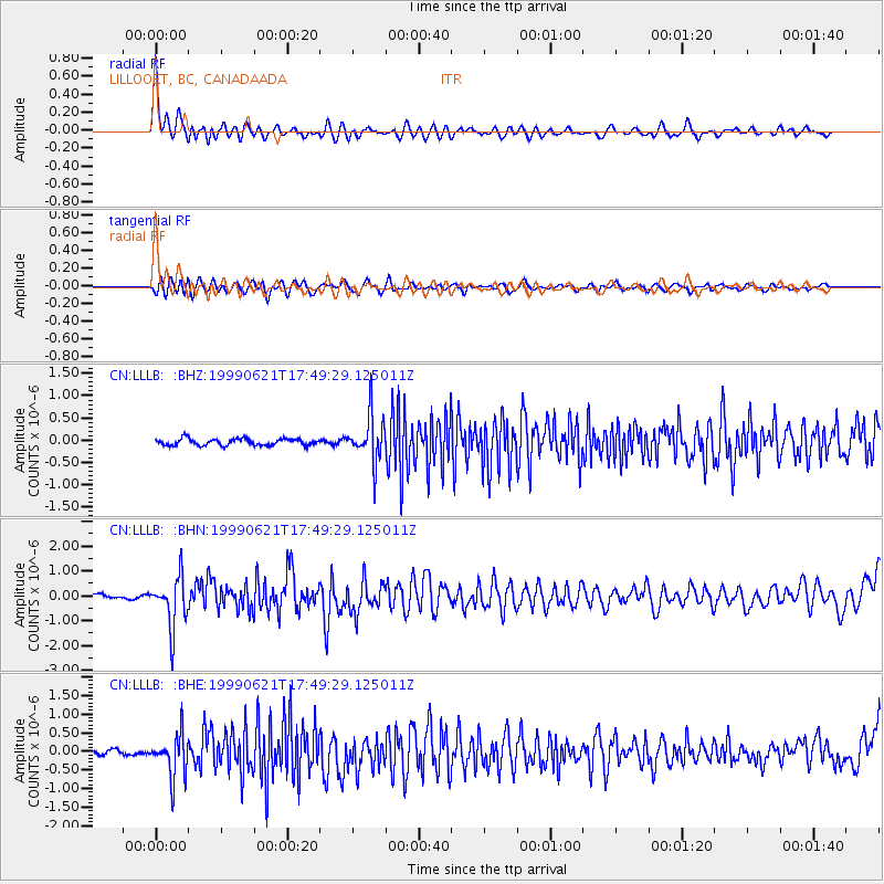
| Earthquake location: |
Guerrero, Mexico |
| Earthquake latitude/longitude: |
18.3/-101.5 |
| Earthquake time(UTC): |
1999/06/21 (172) 17:43:04 GMT |
| Earthquake Depth: |
69 km |
| Earthquake Magnitude: |
6.0 MB, 5.8 MS, 6.3 MW, 5.8 MD |
| Earthquake Catalog/Contributor: |
WHDF/NEIC |
|
| Network: |
CN Canadian National Seismograph Network |
| Station: |
LLLB LILLOOET, BC, CANADA ADA |
| Lat/Lon: |
50.61 N/121.88 W |
| Elevation: |
700 m |
|
| Distance: |
36.1 deg |
| Az: |
337.899 deg |
| Baz: |
145.88 deg |
| Ray Param: |
0.07668432 |
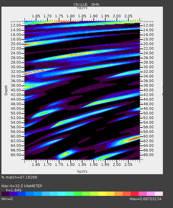
| Estimated Moho Depth: |
32.0 km |
| Estimated Crust Vp/Vs: |
1.64 |
| Assumed Crust Vp: |
6.597 km/s |
| Estimated Crust Vs: |
4.011 km/s |
| Estimated Crust Poisson's Ratio: |
0.21 |
|
| Radial Match: |
87.19289 % |
| Radial Bump: |
400 |
| Transverse Match: |
75.83399 % |
| Transverse Bump: |
400 |
| SOD ConfigId: |
4480 |
| Insert Time: |
2010-02-27 06:36:48.624 +0000 |
| GWidth: |
2.5 |
| Max Bumps: |
400 |
| Tol: |
0.001 |
|
Signal To Noise
| Channel | StoN | STA | LTA |
| CN:LLLB: :BHN:19990621T17:49:29.125011Z | 10.325291 | 1.003152E-6 | 9.7154846E-8 |
| CN:LLLB: :BHE:19990621T17:49:29.125011Z | 5.93696 | 5.657385E-7 | 9.5290936E-8 |
| CN:LLLB: :BHZ:19990621T17:49:29.125011Z | 6.96686 | 5.1236424E-7 | 7.354307E-8 |
| Arrivals |
| Ps | 3.4 SECOND |
| PpPs | 12 SECOND |
| PsPs/PpSs | 15 SECOND |


