You are here: Home > Network List > US - United States National Seismic Network Stations List
> Station HAWA Hanford, Washington, USA > Earthquake Result Viewer
HAWA Hanford, Washington, USA - Earthquake Result Viewer
*The percent match for this event was below the threshold and hence no stack was calculated.
| Earthquake location: |
Guerrero, Mexico |
| Earthquake latitude/longitude: |
17.8/-100.0 |
| Earthquake time(UTC): |
2011/12/11 (345) 01:47:25 GMT |
| Earthquake Depth: |
54 km |
| Earthquake Magnitude: |
6.2 MB, 6.5 MW, 6.5 MW |
| Earthquake Catalog/Contributor: |
WHDF/NEIC |
|
| Network: |
US United States National Seismic Network |
| Station: |
HAWA Hanford, Washington, USA |
| Lat/Lon: |
46.39 N/119.53 W |
| Elevation: |
364 m |
|
| Distance: |
32.8 deg |
| Az: |
334.628 deg |
| Baz: |
143.866 deg |
| Ray Param: |
$rayparam |
*The percent match for this event was below the threshold and hence was not used in the summary stack. |
|
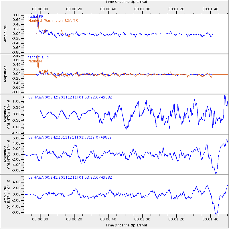
| Radial Match: |
89.50287 % |
| Radial Bump: |
400 |
| Transverse Match: |
60.576664 % |
| Transverse Bump: |
400 |
| SOD ConfigId: |
558545 |
| Insert Time: |
2013-09-19 08:09:28.578 +0000 |
| GWidth: |
2.5 |
| Max Bumps: |
400 |
| Tol: |
0.001 |
|
Signal To Noise
| Channel | StoN | STA | LTA |
| US:HAWA:00:BHZ:20111211T01:53:22.074988Z | 4.4857683 | 1.449194E-6 | 3.2306482E-7 |
| US:HAWA:00:BH1:20111211T01:53:22.074988Z | 2.485229 | 6.976022E-7 | 2.8069937E-7 |
| US:HAWA:00:BH2:20111211T01:53:22.074988Z | 1.8989868 | 3.621751E-7 | 1.9072017E-7 |
| Arrivals |
| Ps | |
| PpPs | |
| PsPs/PpSs | |


