You are here: Home > Network List > US - United States National Seismic Network Stations List
> Station LONY Lake Ozonia, New York, USA > Earthquake Result Viewer
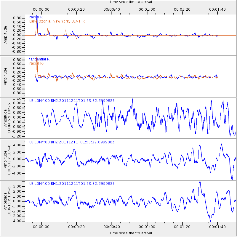
LONY Lake Ozonia, New York, USA - Earthquake Result Viewer
*The percent match for this event was below the threshold and hence no stack was calculated.
| Earthquake location: |
Guerrero, Mexico |
| Earthquake latitude/longitude: |
17.8/-100.0 |
| Earthquake time(UTC): |
2011/12/11 (345) 01:47:25 GMT |
| Earthquake Depth: |
54 km |
| Earthquake Magnitude: |
6.2 MB, 6.5 MW, 6.5 MW |
| Earthquake Catalog/Contributor: |
WHDF/NEIC |
|
| Network: |
US United States National Seismic Network |
| Station: |
LONY Lake Ozonia, New York, USA |
| Lat/Lon: |
44.62 N/74.58 W |
| Elevation: |
440 m |
|
| Distance: |
34.1 deg |
| Az: |
33.062 deg |
| Baz: |
226.687 deg |
| Ray Param: |
$rayparam |
*The percent match for this event was below the threshold and hence was not used in the summary stack. |
|
| Radial Match: |
82.9573 % |
| Radial Bump: |
308 |
| Transverse Match: |
69.056816 % |
| Transverse Bump: |
400 |
| SOD ConfigId: |
558545 |
| Insert Time: |
2013-09-19 08:09:33.640 +0000 |
| GWidth: |
2.5 |
| Max Bumps: |
400 |
| Tol: |
0.001 |
|
Signal To Noise
| Channel | StoN | STA | LTA |
| US:LONY:00:BHZ:20111211T01:53:32.699988Z | 3.9743922 | 1.1236406E-6 | 2.827201E-7 |
| US:LONY:00:BH1:20111211T01:53:32.699988Z | 1.2393565 | 3.9933914E-7 | 3.2221493E-7 |
| US:LONY:00:BH2:20111211T01:53:32.699988Z | 1.3454744 | 5.0608423E-7 | 3.7613816E-7 |
| Arrivals |
| Ps | |
| PpPs | |
| PsPs/PpSs | |


