You are here: Home > Network List > US - United States National Seismic Network Stations List
> Station MSO Missoula, Montana, USA > Earthquake Result Viewer
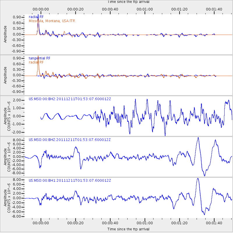
MSO Missoula, Montana, USA - Earthquake Result Viewer
*The percent match for this event was below the threshold and hence no stack was calculated.
| Earthquake location: |
Guerrero, Mexico |
| Earthquake latitude/longitude: |
17.8/-100.0 |
| Earthquake time(UTC): |
2011/12/11 (345) 01:47:25 GMT |
| Earthquake Depth: |
54 km |
| Earthquake Magnitude: |
6.2 MB, 6.5 MW, 6.5 MW |
| Earthquake Catalog/Contributor: |
WHDF/NEIC |
|
| Network: |
US United States National Seismic Network |
| Station: |
MSO Missoula, Montana, USA |
| Lat/Lon: |
46.83 N/113.94 W |
| Elevation: |
1264 m |
|
| Distance: |
31.1 deg |
| Az: |
341.285 deg |
| Baz: |
153.57 deg |
| Ray Param: |
$rayparam |
*The percent match for this event was below the threshold and hence was not used in the summary stack. |
|
| Radial Match: |
88.48274 % |
| Radial Bump: |
362 |
| Transverse Match: |
39.806595 % |
| Transverse Bump: |
400 |
| SOD ConfigId: |
558545 |
| Insert Time: |
2013-09-19 08:09:35.014 +0000 |
| GWidth: |
2.5 |
| Max Bumps: |
400 |
| Tol: |
0.001 |
|
Signal To Noise
| Channel | StoN | STA | LTA |
| US:MSO:00:BHZ:20111211T01:53:07.600012Z | 9.084218 | 2.4977792E-6 | 2.7495807E-7 |
| US:MSO:00:BH1:20111211T01:53:07.600012Z | 5.2942615 | 1.3854511E-6 | 2.6168922E-7 |
| US:MSO:00:BH2:20111211T01:53:07.600012Z | 1.7326165 | 3.8498214E-7 | 2.2219696E-7 |
| Arrivals |
| Ps | |
| PpPs | |
| PsPs/PpSs | |


