You are here: Home > Network List > IU - Global Seismograph Network (GSN - IRIS/USGS) Stations List
> Station PMG Port Moresby, New Guinea > Earthquake Result Viewer
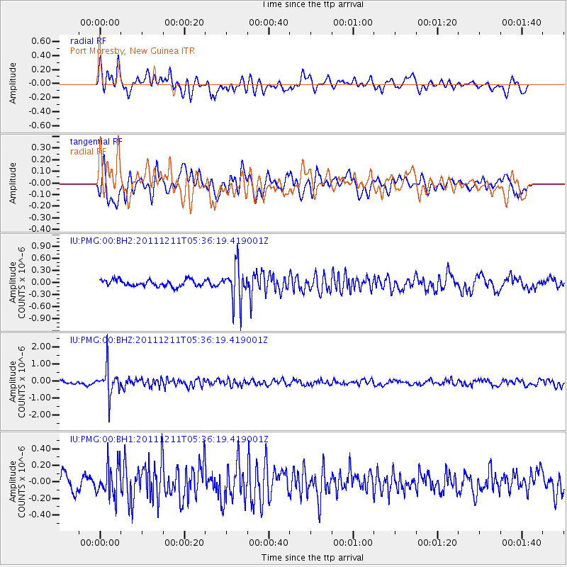
PMG Port Moresby, New Guinea - Earthquake Result Viewer
*The percent match for this event was below the threshold and hence no stack was calculated.
| Earthquake location: |
South Of Fiji Islands |
| Earthquake latitude/longitude: |
-24.1/178.6 |
| Earthquake time(UTC): |
2011/12/11 (345) 05:30:57 GMT |
| Earthquake Depth: |
556 km |
| Earthquake Magnitude: |
5.6 MW, 5.4 MB |
| Earthquake Catalog/Contributor: |
WHDF/NEIC |
|
| Network: |
IU Global Seismograph Network (GSN - IRIS/USGS) |
| Station: |
PMG Port Moresby, New Guinea |
| Lat/Lon: |
9.40 S/147.16 E |
| Elevation: |
90 m |
|
| Distance: |
33.3 deg |
| Az: |
290.619 deg |
| Baz: |
119.897 deg |
| Ray Param: |
$rayparam |
*The percent match for this event was below the threshold and hence was not used in the summary stack. |
|
| Radial Match: |
65.92878 % |
| Radial Bump: |
400 |
| Transverse Match: |
62.395374 % |
| Transverse Bump: |
400 |
| SOD ConfigId: |
558545 |
| Insert Time: |
2013-09-19 08:12:03.807 +0000 |
| GWidth: |
2.5 |
| Max Bumps: |
400 |
| Tol: |
0.001 |
|
Signal To Noise
| Channel | StoN | STA | LTA |
| IU:PMG:00:BHZ:20111211T05:36:19.419001Z | 8.198628 | 8.2468006E-7 | 1.0058756E-7 |
| IU:PMG:00:BH1:20111211T05:36:19.419001Z | 1.919696 | 1.881445E-7 | 9.800745E-8 |
| IU:PMG:00:BH2:20111211T05:36:19.419001Z | 5.5868216 | 4.5031817E-7 | 8.060365E-8 |
| Arrivals |
| Ps | |
| PpPs | |
| PsPs/PpSs | |


