You are here: Home > Network List > US - United States National Seismic Network Stations List
> Station BOZ Bozeman, Montana, USA > Earthquake Result Viewer
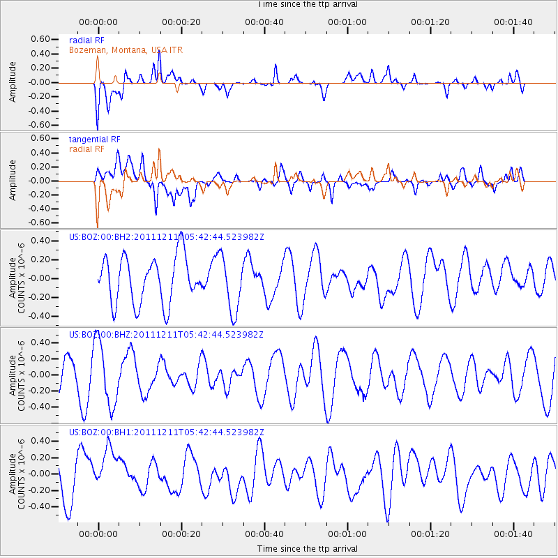
BOZ Bozeman, Montana, USA - Earthquake Result Viewer
*The percent match for this event was below the threshold and hence no stack was calculated.
| Earthquake location: |
South Of Fiji Islands |
| Earthquake latitude/longitude: |
-24.1/178.6 |
| Earthquake time(UTC): |
2011/12/11 (345) 05:30:57 GMT |
| Earthquake Depth: |
556 km |
| Earthquake Magnitude: |
5.6 MW, 5.4 MB |
| Earthquake Catalog/Contributor: |
WHDF/NEIC |
|
| Network: |
US United States National Seismic Network |
| Station: |
BOZ Bozeman, Montana, USA |
| Lat/Lon: |
45.65 N/111.63 W |
| Elevation: |
1589 m |
|
| Distance: |
93.9 deg |
| Az: |
41.294 deg |
| Baz: |
239.298 deg |
| Ray Param: |
$rayparam |
*The percent match for this event was below the threshold and hence was not used in the summary stack. |
|
| Radial Match: |
49.398422 % |
| Radial Bump: |
400 |
| Transverse Match: |
63.546627 % |
| Transverse Bump: |
400 |
| SOD ConfigId: |
558545 |
| Insert Time: |
2013-09-19 08:12:24.698 +0000 |
| GWidth: |
2.5 |
| Max Bumps: |
400 |
| Tol: |
0.001 |
|
Signal To Noise
| Channel | StoN | STA | LTA |
| US:BOZ:00:BHZ:20111211T05:42:44.523982Z | 1.8619272 | 4.0106204E-7 | 2.1540157E-7 |
| US:BOZ:00:BH1:20111211T05:42:44.523982Z | 1.4105781 | 2.9046166E-7 | 2.0591673E-7 |
| US:BOZ:00:BH2:20111211T05:42:44.523982Z | 1.1903791 | 2.9511563E-7 | 2.4791734E-7 |
| Arrivals |
| Ps | |
| PpPs | |
| PsPs/PpSs | |


