You are here: Home > Network List > CN - Canadian National Seismograph Network Stations List
> Station LLLB LILLOOET, BC, CANADA ADA > Earthquake Result Viewer
LLLB LILLOOET, BC, CANADA ADA - Earthquake Result Viewer
| Earthquake location: |
Near West Coast Of Colombia |
| Earthquake latitude/longitude: |
4.7/-77.5 |
| Earthquake time(UTC): |
2004/11/15 (320) 09:06:56 GMT |
| Earthquake Depth: |
15 km |
| Earthquake Magnitude: |
6.6 MB, 7.1 MS, 7.2 MW, 7.1 MW |
| Earthquake Catalog/Contributor: |
WHDF/NEIC |
|
| Network: |
CN Canadian National Seismograph Network |
| Station: |
LLLB LILLOOET, BC, CANADA ADA |
| Lat/Lon: |
50.61 N/121.88 W |
| Elevation: |
700 m |
|
| Distance: |
58.9 deg |
| Az: |
328.641 deg |
| Baz: |
125.506 deg |
| Ray Param: |
0.06253443 |
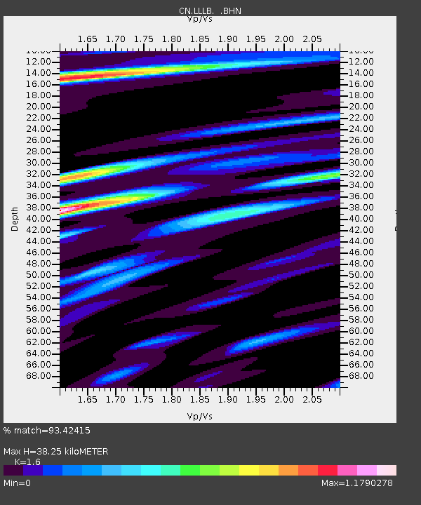
| Estimated Moho Depth: |
38.25 km |
| Estimated Crust Vp/Vs: |
1.60 |
| Assumed Crust Vp: |
6.597 km/s |
| Estimated Crust Vs: |
4.123 km/s |
| Estimated Crust Poisson's Ratio: |
0.18 |
|
| Radial Match: |
93.42415 % |
| Radial Bump: |
400 |
| Transverse Match: |
84.06041 % |
| Transverse Bump: |
400 |
| SOD ConfigId: |
2459 |
| Insert Time: |
2010-02-27 06:36:54.466 +0000 |
| GWidth: |
2.5 |
| Max Bumps: |
400 |
| Tol: |
0.001 |
|
Signal To Noise
| Channel | StoN | STA | LTA |
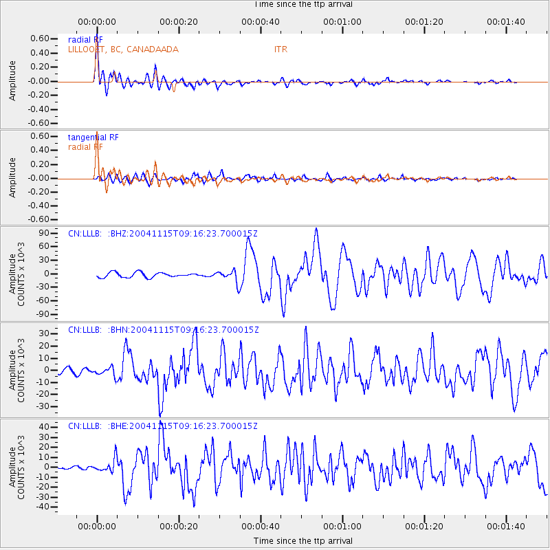
| CN:LLLB: :BHN:20041115T09:16:23.700015Z | 1.011621 | 3563.1147 | 3522.1836 |
| CN:LLLB: :BHE:20041115T09:16:23.700015Z | 2.1498523 | 6840.66 | 3181.921 |
| CN:LLLB: :BHZ:20041115T09:16:23.700015Z | 2.6433775 | 14153.582 | 5354.3555 |
| Arrivals |
| Ps | 3.7 SECOND |
| PpPs | 14 SECOND |
| PsPs/PpSs | 18 SECOND |


