You are here: Home > Network List > IU - Global Seismograph Network (GSN - IRIS/USGS) Stations List
> Station OTAV Otavalo, Ecuador > Earthquake Result Viewer
OTAV Otavalo, Ecuador - Earthquake Result Viewer
| Earthquake location: |
South Sandwich Islands Region |
| Earthquake latitude/longitude: |
-56.0/-28.2 |
| Earthquake time(UTC): |
2011/12/11 (345) 09:54:55 GMT |
| Earthquake Depth: |
116 km |
| Earthquake Magnitude: |
6.1 MB, 6.2 MW, 6.2 MW |
| Earthquake Catalog/Contributor: |
WHDF/NEIC |
|
| Network: |
IU Global Seismograph Network (GSN - IRIS/USGS) |
| Station: |
OTAV Otavalo, Ecuador |
| Lat/Lon: |
0.24 N/78.45 W |
| Elevation: |
3510 m |
|
| Distance: |
69.2 deg |
| Az: |
304.634 deg |
| Baz: |
152.476 deg |
| Ray Param: |
0.055522032 |
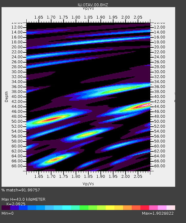
| Estimated Moho Depth: |
43.0 km |
| Estimated Crust Vp/Vs: |
2.09 |
| Assumed Crust Vp: |
6.472 km/s |
| Estimated Crust Vs: |
3.093 km/s |
| Estimated Crust Poisson's Ratio: |
0.35 |
|
| Radial Match: |
91.99757 % |
| Radial Bump: |
400 |
| Transverse Match: |
90.164986 % |
| Transverse Bump: |
400 |
| SOD ConfigId: |
558545 |
| Insert Time: |
2013-09-19 08:14:17.155 +0000 |
| GWidth: |
2.5 |
| Max Bumps: |
400 |
| Tol: |
0.001 |
|

Signal To Noise
| Channel | StoN | STA | LTA |
| IU:OTAV:00:BHZ:20111211T10:05:18.319019Z | 26.198961 | 2.1351623E-6 | 8.1497966E-8 |
| IU:OTAV:00:BH1:20111211T10:05:18.319019Z | 6.682514 | 7.84125E-7 | 1.17339816E-7 |
| IU:OTAV:00:BH2:20111211T10:05:18.319019Z | 6.995947 | 7.0686383E-7 | 1.0103904E-7 |
| Arrivals |
| Ps | 7.5 SECOND |
| PpPs | 20 SECOND |
| PsPs/PpSs | 27 SECOND |


