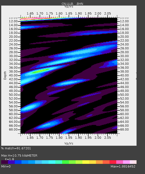
LLLB LILLOOET, BC, CANADA ADA - Earthquake Result Viewer
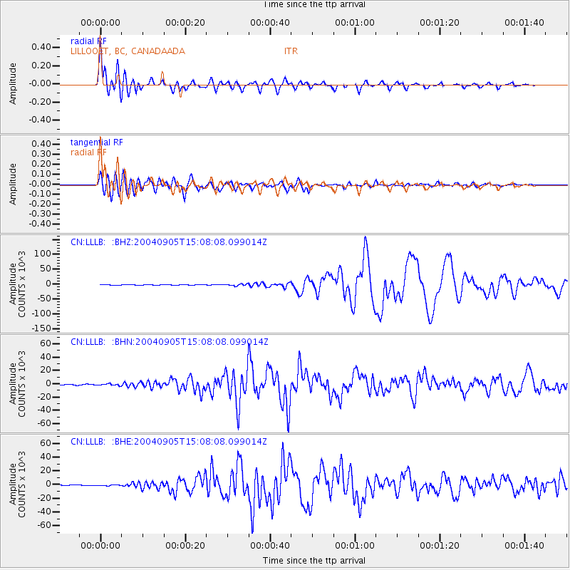
Earthquake location: Near S. Coast Of Honshu, Japan
Earthquake latitude/longitude: 33.2/137.1
Earthquake time(UTC): 2004/09/05 (249) 14:57:18 GMT
Earthquake Depth: 10 km
Earthquake Magnitude: 6.2 MB, 7.1 MS, 7.4 MW, 7.4 MW
Earthquake Catalog/Contributor: WHDF/NEIC
Network: CN Canadian National Seismograph Network
Station: LLLB LILLOOET, BC, CANADA ADA
Lat/Lon: 50.61 N/121.88 W
Elevation: 700 m
Distance: 71.5 deg
Az: 41.259 deg
Baz: 299.778 deg
Ray Param: 0.054293808
Estimated Moho Depth: 10.75 km
Estimated Crust Vp/Vs: 1.60
Assumed Crust Vp: 6.597 km/s
Estimated Crust Vs: 4.123 km/s
Estimated Crust Poisson's Ratio: 0.18
Radial Match: 91.67201 %
Radial Bump: 400
Transverse Match: 91.11587 %
Transverse Bump: 400
SOD ConfigId: 2459
Insert Time: 2010-02-27 06:37:00.278 +0000
GWidth: 2.5
Max Bumps: 400
Tol: 0.001

Signal To Noise

ChannelStoNSTALTA
CN:LLLB: :BHN:20040905T15:08:08.099014Z2.52011731224.0187485.69907
CN:LLLB: :BHE:20040905T15:08:08.099014Z1.4081191663.6457471.29944
CN:LLLB: :BHZ:20040905T15:08:08.099014Z3.75233982800.9153746.445
Arrivals
Ps1.0 SECOND
PpPs4.1 SECOND
PsPs/PpSs5.1 SECOND