You are here: Home > Network List > US - United States National Seismic Network Stations List
> Station EGMT Eagleton, Montana, USA > Earthquake Result Viewer
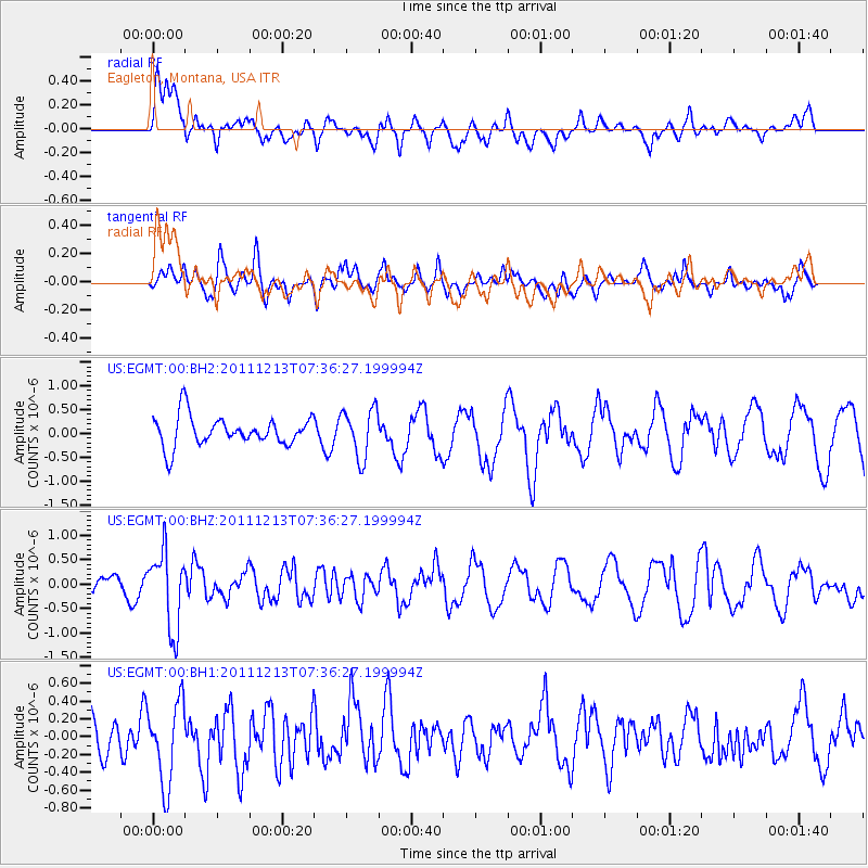
EGMT Eagleton, Montana, USA - Earthquake Result Viewer
*The percent match for this event was below the threshold and hence no stack was calculated.
| Earthquake location: |
South Of Panama |
| Earthquake latitude/longitude: |
4.8/-82.6 |
| Earthquake time(UTC): |
2011/12/13 (347) 07:28:11 GMT |
| Earthquake Depth: |
7.0 km |
| Earthquake Magnitude: |
5.5 MW, 5.5 MB |
| Earthquake Catalog/Contributor: |
NEIC PDE/NEIC PDE-M |
|
| Network: |
US United States National Seismic Network |
| Station: |
EGMT Eagleton, Montana, USA |
| Lat/Lon: |
48.02 N/109.75 W |
| Elevation: |
1055 m |
|
| Distance: |
49.0 deg |
| Az: |
336.027 deg |
| Baz: |
142.9 deg |
| Ray Param: |
$rayparam |
*The percent match for this event was below the threshold and hence was not used in the summary stack. |
|
| Radial Match: |
54.745594 % |
| Radial Bump: |
400 |
| Transverse Match: |
48.700138 % |
| Transverse Bump: |
400 |
| SOD ConfigId: |
558545 |
| Insert Time: |
2013-09-19 08:17:53.603 +0000 |
| GWidth: |
2.5 |
| Max Bumps: |
400 |
| Tol: |
0.001 |
|
Signal To Noise
| Channel | StoN | STA | LTA |
| US:EGMT:00:BHZ:20111213T07:36:27.199994Z | 4.6197815 | 7.9513876E-7 | 1.7211609E-7 |
| US:EGMT:00:BH1:20111213T07:36:27.199994Z | 1.1337262 | 4.6919493E-7 | 4.1385204E-7 |
| US:EGMT:00:BH2:20111213T07:36:27.199994Z | 1.643162 | 5.1414736E-7 | 3.129012E-7 |
| Arrivals |
| Ps | |
| PpPs | |
| PsPs/PpSs | |


