You are here: Home > Network List > US - United States National Seismic Network Stations List
> Station MSO Missoula, Montana, USA > Earthquake Result Viewer
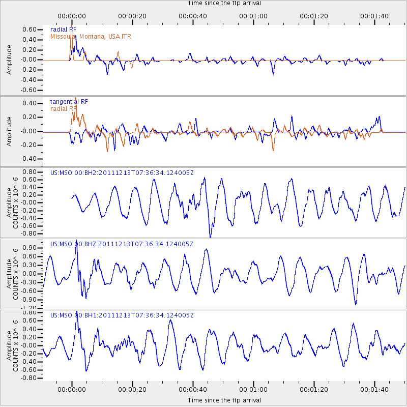
MSO Missoula, Montana, USA - Earthquake Result Viewer
*The percent match for this event was below the threshold and hence no stack was calculated.
| Earthquake location: |
South Of Panama |
| Earthquake latitude/longitude: |
4.8/-82.6 |
| Earthquake time(UTC): |
2011/12/13 (347) 07:28:11 GMT |
| Earthquake Depth: |
7.0 km |
| Earthquake Magnitude: |
5.5 MW, 5.5 MB |
| Earthquake Catalog/Contributor: |
NEIC PDE/NEIC PDE-M |
|
| Network: |
US United States National Seismic Network |
| Station: |
MSO Missoula, Montana, USA |
| Lat/Lon: |
46.83 N/113.94 W |
| Elevation: |
1264 m |
|
| Distance: |
49.9 deg |
| Az: |
332.148 deg |
| Baz: |
137.304 deg |
| Ray Param: |
$rayparam |
*The percent match for this event was below the threshold and hence was not used in the summary stack. |
|
| Radial Match: |
80.12704 % |
| Radial Bump: |
386 |
| Transverse Match: |
60.933445 % |
| Transverse Bump: |
400 |
| SOD ConfigId: |
558545 |
| Insert Time: |
2013-09-19 08:18:26.649 +0000 |
| GWidth: |
2.5 |
| Max Bumps: |
400 |
| Tol: |
0.001 |
|
Signal To Noise
| Channel | StoN | STA | LTA |
| US:MSO:00:BHZ:20111213T07:36:34.124005Z | 1.4262313 | 5.3247345E-7 | 3.7334297E-7 |
| US:MSO:00:BH1:20111213T07:36:34.124005Z | 2.8867967 | 3.8381106E-7 | 1.3295396E-7 |
| US:MSO:00:BH2:20111213T07:36:34.124005Z | 1.3387109 | 3.4374048E-7 | 2.5676977E-7 |
| Arrivals |
| Ps | |
| PpPs | |
| PsPs/PpSs | |


