You are here: Home > Network List > IU - Global Seismograph Network (GSN - IRIS/USGS) Stations List
> Station HNR Honiara, Solomon Islands > Earthquake Result Viewer
HNR Honiara, Solomon Islands - Earthquake Result Viewer
| Earthquake location: |
Minahassa Peninsula, Sulawesi |
| Earthquake latitude/longitude: |
0.0/123.0 |
| Earthquake time(UTC): |
2011/12/13 (347) 07:52:11 GMT |
| Earthquake Depth: |
161 km |
| Earthquake Magnitude: |
6.3 MB, 6.0 MW, 6.0 MW |
| Earthquake Catalog/Contributor: |
WHDF/NEIC |
|
| Network: |
IU Global Seismograph Network (GSN - IRIS/USGS) |
| Station: |
HNR Honiara, Solomon Islands |
| Lat/Lon: |
9.44 S/159.95 E |
| Elevation: |
100 m |
|
| Distance: |
37.9 deg |
| Az: |
105.422 deg |
| Baz: |
282.299 deg |
| Ray Param: |
0.075261936 |
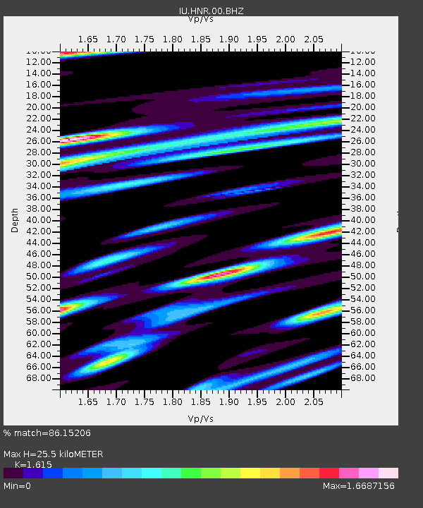
| Estimated Moho Depth: |
25.5 km |
| Estimated Crust Vp/Vs: |
1.62 |
| Assumed Crust Vp: |
6.183 km/s |
| Estimated Crust Vs: |
3.828 km/s |
| Estimated Crust Poisson's Ratio: |
0.19 |
|
| Radial Match: |
86.15206 % |
| Radial Bump: |
400 |
| Transverse Match: |
87.0396 % |
| Transverse Bump: |
400 |
| SOD ConfigId: |
558545 |
| Insert Time: |
2013-09-19 08:20:23.696 +0000 |
| GWidth: |
2.5 |
| Max Bumps: |
400 |
| Tol: |
0.001 |
|
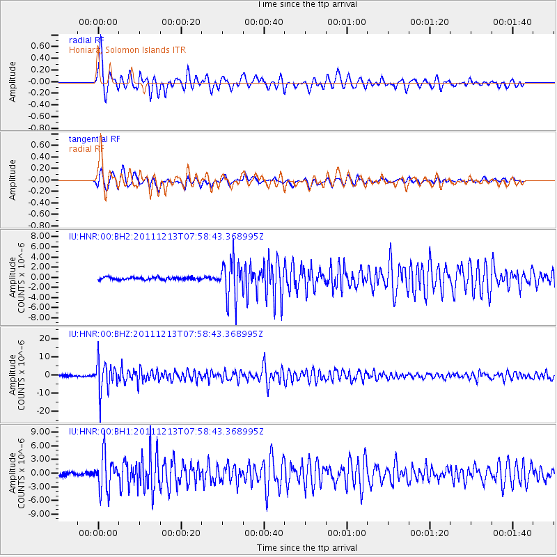
Signal To Noise
| Channel | StoN | STA | LTA |
| IU:HNR:00:BHZ:20111213T07:58:43.368995Z | 27.814728 | 8.31927E-6 | 2.9909586E-7 |
| IU:HNR:00:BH1:20111213T07:58:43.368995Z | 14.8270645 | 3.913729E-6 | 2.6395844E-7 |
| IU:HNR:00:BH2:20111213T07:58:43.368995Z | 15.668047 | 3.8174526E-6 | 2.4364573E-7 |
| Arrivals |
| Ps | 2.7 SECOND |
| PpPs | 10 SECOND |
| PsPs/PpSs | 13 SECOND |


