You are here: Home > Network List > IU - Global Seismograph Network (GSN - IRIS/USGS) Stations List
> Station POHA Pohakuloa, Hawaii, USA > Earthquake Result Viewer
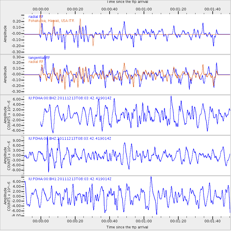
POHA Pohakuloa, Hawaii, USA - Earthquake Result Viewer
*The percent match for this event was below the threshold and hence no stack was calculated.
| Earthquake location: |
Minahassa Peninsula, Sulawesi |
| Earthquake latitude/longitude: |
0.0/123.0 |
| Earthquake time(UTC): |
2011/12/13 (347) 07:52:11 GMT |
| Earthquake Depth: |
161 km |
| Earthquake Magnitude: |
6.3 MB, 6.0 MW, 6.0 MW |
| Earthquake Catalog/Contributor: |
WHDF/NEIC |
|
| Network: |
IU Global Seismograph Network (GSN - IRIS/USGS) |
| Station: |
POHA Pohakuloa, Hawaii, USA |
| Lat/Lon: |
19.76 N/155.53 W |
| Elevation: |
1990 m |
|
| Distance: |
81.9 deg |
| Az: |
70.166 deg |
| Baz: |
267.142 deg |
| Ray Param: |
$rayparam |
*The percent match for this event was below the threshold and hence was not used in the summary stack. |
|
| Radial Match: |
38.296913 % |
| Radial Bump: |
400 |
| Transverse Match: |
56.323574 % |
| Transverse Bump: |
400 |
| SOD ConfigId: |
558545 |
| Insert Time: |
2013-09-19 08:20:52.216 +0000 |
| GWidth: |
2.5 |
| Max Bumps: |
400 |
| Tol: |
0.001 |
|
Signal To Noise
| Channel | StoN | STA | LTA |
| IU:POHA:00:BHZ:20111213T08:03:42.419014Z | 2.3226864 | 4.253135E-6 | 1.8311274E-6 |
| IU:POHA:00:BH1:20111213T08:03:42.419014Z | 0.99923927 | 2.4422438E-6 | 2.444103E-6 |
| IU:POHA:00:BH2:20111213T08:03:42.419014Z | 1.1856906 | 2.921057E-6 | 2.4635913E-6 |
| Arrivals |
| Ps | |
| PpPs | |
| PsPs/PpSs | |


