You are here: Home > Network List > IU - Global Seismograph Network (GSN - IRIS/USGS) Stations List
> Station SNZO South Karori, New Zealand > Earthquake Result Viewer
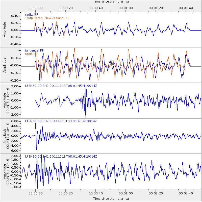
SNZO South Karori, New Zealand - Earthquake Result Viewer
*The percent match for this event was below the threshold and hence no stack was calculated.
| Earthquake location: |
Minahassa Peninsula, Sulawesi |
| Earthquake latitude/longitude: |
0.0/123.0 |
| Earthquake time(UTC): |
2011/12/13 (347) 07:52:11 GMT |
| Earthquake Depth: |
161 km |
| Earthquake Magnitude: |
6.3 MB, 6.0 MW, 6.0 MW |
| Earthquake Catalog/Contributor: |
WHDF/NEIC |
|
| Network: |
IU Global Seismograph Network (GSN - IRIS/USGS) |
| Station: |
SNZO South Karori, New Zealand |
| Lat/Lon: |
41.31 S/174.70 E |
| Elevation: |
120 m |
|
| Distance: |
62.2 deg |
| Az: |
138.068 deg |
| Baz: |
297.498 deg |
| Ray Param: |
$rayparam |
*The percent match for this event was below the threshold and hence was not used in the summary stack. |
|
| Radial Match: |
64.209885 % |
| Radial Bump: |
400 |
| Transverse Match: |
52.772133 % |
| Transverse Bump: |
400 |
| SOD ConfigId: |
558545 |
| Insert Time: |
2013-09-19 08:20:59.207 +0000 |
| GWidth: |
2.5 |
| Max Bumps: |
400 |
| Tol: |
0.001 |
|
Signal To Noise
| Channel | StoN | STA | LTA |
| IU:SNZO:00:BHZ:20111213T08:01:45.419014Z | 8.859045 | 2.5710576E-6 | 2.9021837E-7 |
| IU:SNZO:00:BH1:20111213T08:01:45.419014Z | 2.168959 | 1.0313935E-6 | 4.755247E-7 |
| IU:SNZO:00:BH2:20111213T08:01:45.419014Z | 2.192466 | 9.2435477E-7 | 4.2160502E-7 |
| Arrivals |
| Ps | |
| PpPs | |
| PsPs/PpSs | |


