You are here: Home > Network List > US - United States National Seismic Network Stations List
> Station DGMT Dagmar, Montana, USA > Earthquake Result Viewer
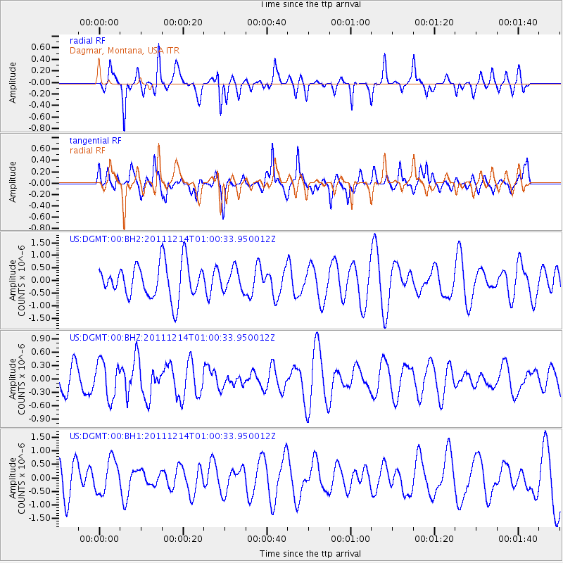
DGMT Dagmar, Montana, USA - Earthquake Result Viewer
*The percent match for this event was below the threshold and hence no stack was calculated.
| Earthquake location: |
Tonga Islands |
| Earthquake latitude/longitude: |
-15.4/-174.8 |
| Earthquake time(UTC): |
2011/12/14 (348) 00:48:10 GMT |
| Earthquake Depth: |
10 km |
| Earthquake Magnitude: |
5.8 MW, 5.6 MS |
| Earthquake Catalog/Contributor: |
NEIC PDE/NEIC PDE-M |
|
| Network: |
US United States National Seismic Network |
| Station: |
DGMT Dagmar, Montana, USA |
| Lat/Lon: |
48.47 N/104.20 W |
| Elevation: |
0.0 m |
|
| Distance: |
89.1 deg |
| Az: |
38.897 deg |
| Baz: |
245.527 deg |
| Ray Param: |
$rayparam |
*The percent match for this event was below the threshold and hence was not used in the summary stack. |
|
| Radial Match: |
55.159134 % |
| Radial Bump: |
342 |
| Transverse Match: |
56.583103 % |
| Transverse Bump: |
394 |
| SOD ConfigId: |
558545 |
| Insert Time: |
2013-09-19 08:24:34.281 +0000 |
| GWidth: |
2.5 |
| Max Bumps: |
400 |
| Tol: |
0.001 |
|
Signal To Noise
| Channel | StoN | STA | LTA |
| US:DGMT:00:BHZ:20111214T01:00:33.950012Z | 1.7470325 | 4.2186647E-7 | 2.4147604E-7 |
| US:DGMT:00:BH1:20111214T01:00:33.950012Z | 0.768665 | 6.3137963E-7 | 8.2139763E-7 |
| US:DGMT:00:BH2:20111214T01:00:33.950012Z | 0.6427288 | 4.4460137E-7 | 6.9174024E-7 |
| Arrivals |
| Ps | |
| PpPs | |
| PsPs/PpSs | |


