You are here: Home > Network List > US - United States National Seismic Network Stations List
> Station DUG Dugway, Tooele County, Utah, USA > Earthquake Result Viewer
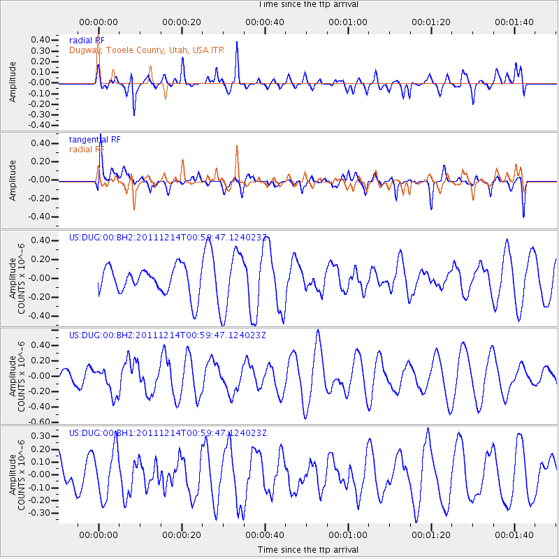
DUG Dugway, Tooele County, Utah, USA - Earthquake Result Viewer
*The percent match for this event was below the threshold and hence no stack was calculated.
| Earthquake location: |
Tonga Islands |
| Earthquake latitude/longitude: |
-15.4/-174.8 |
| Earthquake time(UTC): |
2011/12/14 (348) 00:48:10 GMT |
| Earthquake Depth: |
10 km |
| Earthquake Magnitude: |
5.8 MW, 5.6 MS |
| Earthquake Catalog/Contributor: |
NEIC PDE/NEIC PDE-M |
|
| Network: |
US United States National Seismic Network |
| Station: |
DUG Dugway, Tooele County, Utah, USA |
| Lat/Lon: |
40.19 N/112.81 W |
| Elevation: |
1477 m |
|
| Distance: |
79.8 deg |
| Az: |
43.416 deg |
| Baz: |
239.943 deg |
| Ray Param: |
$rayparam |
*The percent match for this event was below the threshold and hence was not used in the summary stack. |
|
| Radial Match: |
32.006596 % |
| Radial Bump: |
389 |
| Transverse Match: |
46.231823 % |
| Transverse Bump: |
400 |
| SOD ConfigId: |
558545 |
| Insert Time: |
2013-09-19 08:24:34.912 +0000 |
| GWidth: |
2.5 |
| Max Bumps: |
400 |
| Tol: |
0.001 |
|
Signal To Noise
| Channel | StoN | STA | LTA |
| US:DUG:00:BHZ:20111214T00:59:47.124023Z | 1.7990805 | 1.7777214E-7 | 9.881278E-8 |
| US:DUG:00:BH1:20111214T00:59:47.124023Z | 1.4658215 | 1.9066341E-7 | 1.3007273E-7 |
| US:DUG:00:BH2:20111214T00:59:47.124023Z | 2.223847 | 3.229742E-7 | 1.452322E-7 |
| Arrivals |
| Ps | |
| PpPs | |
| PsPs/PpSs | |


