You are here: Home > Network List > ER - Mount Erebus Volcano Observatory Seismic Network Stations List
> Station HOO Hoopers Shoulder,Mt Erebus Volcano Observatory Network, > Earthquake Result Viewer
HOO Hoopers Shoulder,Mt Erebus Volcano Observatory Network, - Earthquake Result Viewer
| Earthquake location: |
Eastern New Guinea Reg., P.N.G. |
| Earthquake latitude/longitude: |
-7.6/146.8 |
| Earthquake time(UTC): |
2011/12/14 (348) 05:04:59 GMT |
| Earthquake Depth: |
141 km |
| Earthquake Magnitude: |
6.6 MB, 7.1 MW, 7.1 MW |
| Earthquake Catalog/Contributor: |
WHDF/NEIC |
|
| Network: |
ER Mount Erebus Volcano Observatory Seismic Network |
| Station: |
HOO Hoopers Shoulder,Mt Erebus Volcano Observatory Network, |
| Lat/Lon: |
77.53 S/166.93 E |
| Elevation: |
2069 m |
|
| Distance: |
70.7 deg |
| Az: |
175.457 deg |
| Baz: |
338.814 deg |
| Ray Param: |
0.054420307 |
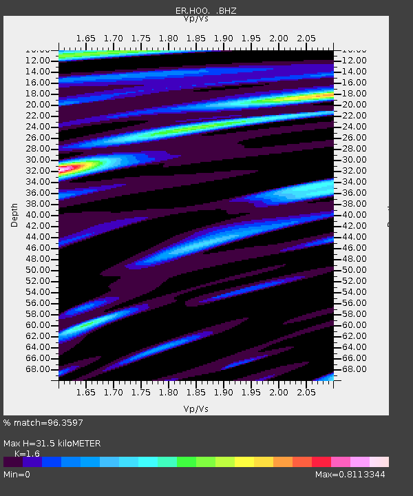
| Estimated Moho Depth: |
31.5 km |
| Estimated Crust Vp/Vs: |
1.60 |
| Assumed Crust Vp: |
6.183 km/s |
| Estimated Crust Vs: |
3.864 km/s |
| Estimated Crust Poisson's Ratio: |
0.18 |
|
| Radial Match: |
96.3597 % |
| Radial Bump: |
400 |
| Transverse Match: |
89.87701 % |
| Transverse Bump: |
400 |
| SOD ConfigId: |
558545 |
| Insert Time: |
2013-09-19 08:27:01.796 +0000 |
| GWidth: |
2.5 |
| Max Bumps: |
400 |
| Tol: |
0.001 |
|

Signal To Noise
| Channel | StoN | STA | LTA |
| ER:HOO: :BHZ:20111214T05:15:29.275005Z | 13.631958 | 3.2006387E-6 | 2.3478937E-7 |
| ER:HOO: :BH1:20111214T05:15:29.275005Z | 2.5590458 | 8.202431E-7 | 3.2052694E-7 |
| ER:HOO: :BH2:20111214T05:15:29.275005Z | 5.18889 | 1.58019E-6 | 3.0453333E-7 |
| Arrivals |
| Ps | 3.2 SECOND |
| PpPs | 13 SECOND |
| PsPs/PpSs | 16 SECOND |


