You are here: Home > Network List > II - Global Seismograph Network (GSN - IRIS/IDA) Stations List
> Station PALK Pallekele, Sri Lanka > Earthquake Result Viewer
PALK Pallekele, Sri Lanka - Earthquake Result Viewer
| Earthquake location: |
Eastern New Guinea Reg., P.N.G. |
| Earthquake latitude/longitude: |
-7.6/146.8 |
| Earthquake time(UTC): |
2011/12/14 (348) 05:04:59 GMT |
| Earthquake Depth: |
141 km |
| Earthquake Magnitude: |
6.6 MB, 7.1 MW, 7.1 MW |
| Earthquake Catalog/Contributor: |
WHDF/NEIC |
|
| Network: |
II Global Seismograph Network (GSN - IRIS/IDA) |
| Station: |
PALK Pallekele, Sri Lanka |
| Lat/Lon: |
7.27 N/80.70 E |
| Elevation: |
460 m |
|
| Distance: |
67.5 deg |
| Az: |
281.055 deg |
| Baz: |
101.243 deg |
| Ray Param: |
0.056505915 |
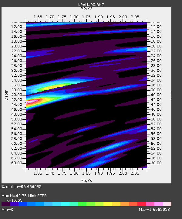
| Estimated Moho Depth: |
42.75 km |
| Estimated Crust Vp/Vs: |
1.61 |
| Assumed Crust Vp: |
6.545 km/s |
| Estimated Crust Vs: |
4.078 km/s |
| Estimated Crust Poisson's Ratio: |
0.18 |
|
| Radial Match: |
95.666985 % |
| Radial Bump: |
400 |
| Transverse Match: |
91.83506 % |
| Transverse Bump: |
400 |
| SOD ConfigId: |
558545 |
| Insert Time: |
2013-09-19 08:27:29.278 +0000 |
| GWidth: |
2.5 |
| Max Bumps: |
400 |
| Tol: |
0.001 |
|
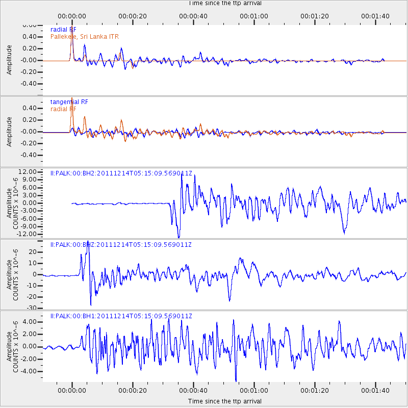
Signal To Noise
| Channel | StoN | STA | LTA |
| II:PALK:00:BHZ:20111214T05:15:09.569011Z | 34.256 | 8.105616E-6 | 2.3661886E-7 |
| II:PALK:00:BH1:20111214T05:15:09.569011Z | 6.9772716 | 8.5554603E-7 | 1.22619E-7 |
| II:PALK:00:BH2:20111214T05:15:09.569011Z | 21.615553 | 3.508019E-6 | 1.6229143E-7 |
| Arrivals |
| Ps | 4.1 SECOND |
| PpPs | 16 SECOND |
| PsPs/PpSs | 20 SECOND |


