You are here: Home > Network List > IU - Global Seismograph Network (GSN - IRIS/USGS) Stations List
> Station FUNA Funafuti, Tuvalu > Earthquake Result Viewer
FUNA Funafuti, Tuvalu - Earthquake Result Viewer
| Earthquake location: |
Eastern New Guinea Reg., P.N.G. |
| Earthquake latitude/longitude: |
-7.6/146.8 |
| Earthquake time(UTC): |
2011/12/14 (348) 05:04:59 GMT |
| Earthquake Depth: |
141 km |
| Earthquake Magnitude: |
6.6 MB, 7.1 MW, 7.1 MW |
| Earthquake Catalog/Contributor: |
WHDF/NEIC |
|
| Network: |
IU Global Seismograph Network (GSN - IRIS/USGS) |
| Station: |
FUNA Funafuti, Tuvalu |
| Lat/Lon: |
8.53 S/179.20 E |
| Elevation: |
20 m |
|
| Distance: |
32.1 deg |
| Az: |
93.978 deg |
| Baz: |
269.354 deg |
| Ray Param: |
0.078403026 |
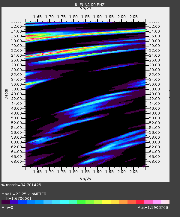
| Estimated Moho Depth: |
23.25 km |
| Estimated Crust Vp/Vs: |
1.67 |
| Assumed Crust Vp: |
4.24 km/s |
| Estimated Crust Vs: |
2.539 km/s |
| Estimated Crust Poisson's Ratio: |
0.22 |
|
| Radial Match: |
84.781425 % |
| Radial Bump: |
381 |
| Transverse Match: |
78.312294 % |
| Transverse Bump: |
400 |
| SOD ConfigId: |
558545 |
| Insert Time: |
2013-09-19 08:27:51.778 +0000 |
| GWidth: |
2.5 |
| Max Bumps: |
400 |
| Tol: |
0.001 |
|
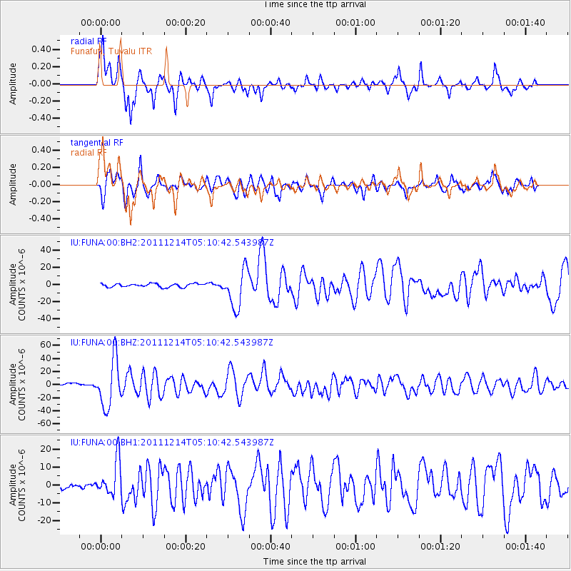
Signal To Noise
| Channel | StoN | STA | LTA |
| IU:FUNA:00:BHZ:20111214T05:10:42.543987Z | 18.827744 | 3.721918E-5 | 1.9768263E-6 |
| IU:FUNA:00:BH1:20111214T05:10:42.543987Z | 8.137204 | 1.0259017E-5 | 1.2607544E-6 |
| IU:FUNA:00:BH2:20111214T05:10:42.543987Z | 11.39259 | 2.2974598E-5 | 2.0166265E-6 |
| Arrivals |
| Ps | 3.8 SECOND |
| PpPs | 14 SECOND |
| PsPs/PpSs | 18 SECOND |


