You are here: Home > Network List > IU - Global Seismograph Network (GSN - IRIS/USGS) Stations List
> Station KIP Kipapa, Hawaii, USA > Earthquake Result Viewer
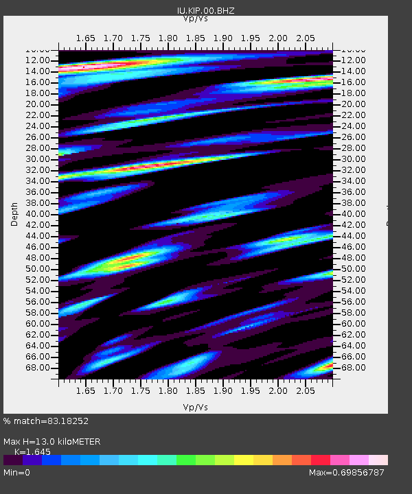
KIP Kipapa, Hawaii, USA - Earthquake Result Viewer
| Earthquake location: |
Eastern New Guinea Reg., P.N.G. |
| Earthquake latitude/longitude: |
-7.6/146.8 |
| Earthquake time(UTC): |
2011/12/14 (348) 05:04:59 GMT |
| Earthquake Depth: |
141 km |
| Earthquake Magnitude: |
6.6 MB, 7.1 MW, 7.1 MW |
| Earthquake Catalog/Contributor: |
WHDF/NEIC |
|
| Network: |
IU Global Seismograph Network (GSN - IRIS/USGS) |
| Station: |
KIP Kipapa, Hawaii, USA |
| Lat/Lon: |
21.42 N/158.01 W |
| Elevation: |
110 m |
|
| Distance: |
61.3 deg |
| Az: |
60.687 deg |
| Baz: |
248.094 deg |
| Ray Param: |
0.060542658 |
| Estimated Moho Depth: |
13.0 km |
| Estimated Crust Vp/Vs: |
1.64 |
| Assumed Crust Vp: |
4.24 km/s |
| Estimated Crust Vs: |
2.577 km/s |
| Estimated Crust Poisson's Ratio: |
0.21 |
|
| Radial Match: |
83.18252 % |
| Radial Bump: |
400 |
| Transverse Match: |
68.227875 % |
| Transverse Bump: |
400 |
| SOD ConfigId: |
558545 |
| Insert Time: |
2013-09-19 08:27:59.857 +0000 |
| GWidth: |
2.5 |
| Max Bumps: |
400 |
| Tol: |
0.001 |
|

Signal To Noise
| Channel | StoN | STA | LTA |
| IU:KIP:00:BHZ:20111214T05:14:29.118999Z | 2.6291687 | 1.0883953E-5 | 4.1396934E-6 |
| IU:KIP:00:BH1:20111214T05:14:29.118999Z | 1.2051352 | 3.0098465E-6 | 2.4975175E-6 |
| IU:KIP:00:BH2:20111214T05:14:29.118999Z | 2.811639 | 8.82014E-6 | 3.1370098E-6 |
| Arrivals |
| Ps | 2.0 SECOND |
| PpPs | 7.9 SECOND |
| PsPs/PpSs | 10.0 SECOND |


