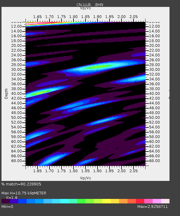
LLLB LILLOOET, BC, CANADA ADA - Earthquake Result Viewer
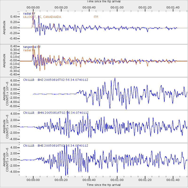
Earthquake location: Near East Coast Of Honshu, Japan
Earthquake latitude/longitude: 38.3/142.0
Earthquake time(UTC): 2005/08/16 (228) 02:46:28 GMT
Earthquake Depth: 36 km
Earthquake Magnitude: 6.5 MB, 6.8 MS, 7.2 MW, 7.1 MW
Earthquake Catalog/Contributor: WHDF/NEIC
Network: CN Canadian National Seismograph Network
Station: LLLB LILLOOET, BC, CANADA ADA
Lat/Lon: 50.61 N/121.88 W
Elevation: 700 m
Distance: 65.0 deg
Az: 44.344 deg
Baz: 300.298 deg
Ray Param: 0.05848687
Estimated Moho Depth: 10.75 km
Estimated Crust Vp/Vs: 1.60
Assumed Crust Vp: 6.597 km/s
Estimated Crust Vs: 4.123 km/s
Estimated Crust Poisson's Ratio: 0.18
Radial Match: 90.228905 %
Radial Bump: 400
Transverse Match: 86.490105 %
Transverse Bump: 400
SOD ConfigId: 2669
Insert Time: 2010-02-27 06:37:28.400 +0000
GWidth: 2.5
Max Bumps: 400
Tol: 0.001

Signal To Noise

ChannelStoNSTALTA
CN:LLLB: :BHN:20050816T02:56:34.074011Z6.46356062.5888448E-74.005292E-8
CN:LLLB: :BHE:20050816T02:56:34.074011Z6.6084613.0205075E-74.570667E-8
CN:LLLB: :BHZ:20050816T02:56:34.074011Z13.0108537.877183E-76.054317E-8
Arrivals
Ps1.0 SECOND
PpPs4.0 SECOND
PsPs/PpSs5.1 SECOND