You are here: Home > Network List > II - Global Seismograph Network (GSN - IRIS/IDA) Stations List
> Station WRAB Tennant Creek, NT, Australia > Earthquake Result Viewer
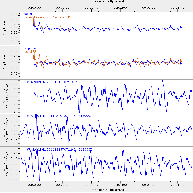
WRAB Tennant Creek, NT, Australia - Earthquake Result Viewer
*The percent match for this event was below the threshold and hence no stack was calculated.
| Earthquake location: |
Kermadec Islands Region |
| Earthquake latitude/longitude: |
-29.5/-176.3 |
| Earthquake time(UTC): |
2011/12/15 (349) 07:12:08 GMT |
| Earthquake Depth: |
30 km |
| Earthquake Magnitude: |
5.5 MB |
| Earthquake Catalog/Contributor: |
NEIC PDE/NEIC PDE-M |
|
| Network: |
II Global Seismograph Network (GSN - IRIS/IDA) |
| Station: |
WRAB Tennant Creek, NT, Australia |
| Lat/Lon: |
19.93 S/134.36 E |
| Elevation: |
366 m |
|
| Distance: |
45.5 deg |
| Az: |
270.392 deg |
| Baz: |
112.081 deg |
| Ray Param: |
$rayparam |
*The percent match for this event was below the threshold and hence was not used in the summary stack. |
|
| Radial Match: |
72.11349 % |
| Radial Bump: |
352 |
| Transverse Match: |
66.08876 % |
| Transverse Bump: |
400 |
| SOD ConfigId: |
558545 |
| Insert Time: |
2013-09-19 08:32:59.271 +0000 |
| GWidth: |
2.5 |
| Max Bumps: |
400 |
| Tol: |
0.001 |
|
Signal To Noise
| Channel | StoN | STA | LTA |
| II:WRAB:00:BHZ:20111215T07:19:54.218999Z | 2.5139813 | 3.048622E-7 | 1.2126668E-7 |
| II:WRAB:00:BH1:20111215T07:19:54.218999Z | 1.9218352 | 1.7493288E-7 | 9.102387E-8 |
| II:WRAB:00:BH2:20111215T07:19:54.218999Z | 1.7174743 | 1.8321316E-7 | 1.0667593E-7 |
| Arrivals |
| Ps | |
| PpPs | |
| PsPs/PpSs | |


