You are here: Home > Network List > IU - Global Seismograph Network (GSN - IRIS/USGS) Stations List
> Station HNR Honiara, Solomon Islands > Earthquake Result Viewer
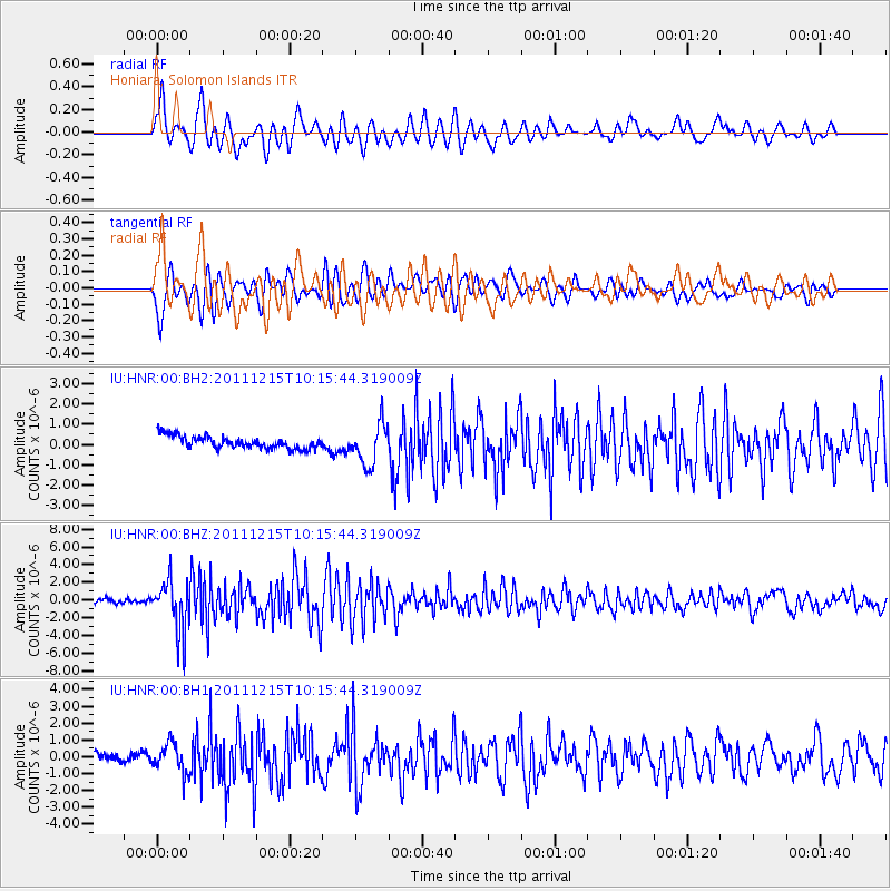
HNR Honiara, Solomon Islands - Earthquake Result Viewer
*The percent match for this event was below the threshold and hence no stack was calculated.
| Earthquake location: |
South Of Kermadec Islands |
| Earthquake latitude/longitude: |
-32.7/-179.1 |
| Earthquake time(UTC): |
2011/12/15 (349) 10:10:07 GMT |
| Earthquake Depth: |
32 km |
| Earthquake Magnitude: |
5.8 MB, 5.7 MS, 6.0 MW, 5.9 MW |
| Earthquake Catalog/Contributor: |
WHDF/NEIC |
|
| Network: |
IU Global Seismograph Network (GSN - IRIS/USGS) |
| Station: |
HNR Honiara, Solomon Islands |
| Lat/Lon: |
9.44 S/159.95 E |
| Elevation: |
100 m |
|
| Distance: |
30.2 deg |
| Az: |
315.441 deg |
| Baz: |
143.167 deg |
| Ray Param: |
$rayparam |
*The percent match for this event was below the threshold and hence was not used in the summary stack. |
|
| Radial Match: |
77.41632 % |
| Radial Bump: |
400 |
| Transverse Match: |
67.209984 % |
| Transverse Bump: |
400 |
| SOD ConfigId: |
558545 |
| Insert Time: |
2013-09-19 08:36:11.320 +0000 |
| GWidth: |
2.5 |
| Max Bumps: |
400 |
| Tol: |
0.001 |
|
Signal To Noise
| Channel | StoN | STA | LTA |
| IU:HNR:00:BHZ:20111215T10:15:44.319009Z | 11.247753 | 2.875186E-6 | 2.5562315E-7 |
| IU:HNR:00:BH1:20111215T10:15:44.319009Z | 4.077368 | 8.6084657E-7 | 2.1112801E-7 |
| IU:HNR:00:BH2:20111215T10:15:44.319009Z | 3.2775986 | 9.99397E-7 | 3.0491745E-7 |
| Arrivals |
| Ps | |
| PpPs | |
| PsPs/PpSs | |


