You are here: Home > Network List > II - Global Seismograph Network (GSN - IRIS/IDA) Stations List
> Station AAK Ala Archa, Kyrgyzstan > Earthquake Result Viewer
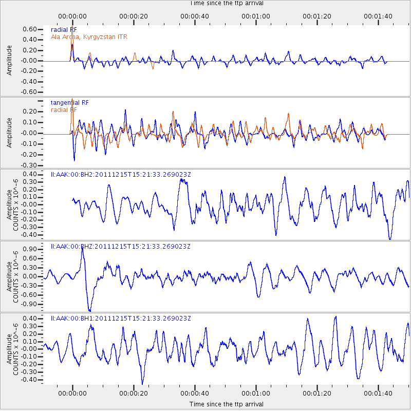
AAK Ala Archa, Kyrgyzstan - Earthquake Result Viewer
*The percent match for this event was below the threshold and hence no stack was calculated.
| Earthquake location: |
Southeast Of Honshu, Japan |
| Earthquake latitude/longitude: |
31.7/141.6 |
| Earthquake time(UTC): |
2011/12/15 (349) 15:12:48 GMT |
| Earthquake Depth: |
35 km |
| Earthquake Magnitude: |
5.6 MW, 5.5 MS, 5.6 MW |
| Earthquake Catalog/Contributor: |
NEIC PDE/NEIC PDE-M |
|
| Network: |
II Global Seismograph Network (GSN - IRIS/IDA) |
| Station: |
AAK Ala Archa, Kyrgyzstan |
| Lat/Lon: |
42.64 N/74.49 E |
| Elevation: |
1645 m |
|
| Distance: |
53.3 deg |
| Az: |
302.02 deg |
| Baz: |
78.303 deg |
| Ray Param: |
$rayparam |
*The percent match for this event was below the threshold and hence was not used in the summary stack. |
|
| Radial Match: |
58.240944 % |
| Radial Bump: |
400 |
| Transverse Match: |
71.82239 % |
| Transverse Bump: |
400 |
| SOD ConfigId: |
558545 |
| Insert Time: |
2013-09-19 08:38:39.790 +0000 |
| GWidth: |
2.5 |
| Max Bumps: |
400 |
| Tol: |
0.001 |
|
Signal To Noise
| Channel | StoN | STA | LTA |
| II:AAK:00:BHZ:20111215T15:21:33.269023Z | 4.537405 | 4.0112778E-7 | 8.840466E-8 |
| II:AAK:00:BH1:20111215T15:21:33.269023Z | 1.422921 | 1.2872128E-7 | 9.04627E-8 |
| II:AAK:00:BH2:20111215T15:21:33.269023Z | 1.2655725 | 1.340157E-7 | 1.05893335E-7 |
| Arrivals |
| Ps | |
| PpPs | |
| PsPs/PpSs | |


