You are here: Home > Network List > IU - Global Seismograph Network (GSN - IRIS/USGS) Stations List
> Station JOHN Johnston Island, USA > Earthquake Result Viewer
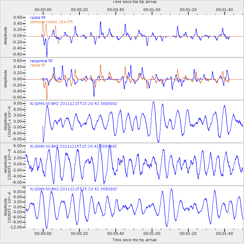
JOHN Johnston Island, USA - Earthquake Result Viewer
*The percent match for this event was below the threshold and hence no stack was calculated.
| Earthquake location: |
Southeast Of Honshu, Japan |
| Earthquake latitude/longitude: |
31.7/141.6 |
| Earthquake time(UTC): |
2011/12/15 (349) 15:12:48 GMT |
| Earthquake Depth: |
35 km |
| Earthquake Magnitude: |
5.6 MW, 5.5 MS, 5.6 MW |
| Earthquake Catalog/Contributor: |
NEIC PDE/NEIC PDE-M |
|
| Network: |
IU Global Seismograph Network (GSN - IRIS/USGS) |
| Station: |
JOHN Johnston Island, USA |
| Lat/Lon: |
16.73 N/169.53 W |
| Elevation: |
2.0 m |
|
| Distance: |
46.6 deg |
| Az: |
96.804 deg |
| Baz: |
297.975 deg |
| Ray Param: |
$rayparam |
*The percent match for this event was below the threshold and hence was not used in the summary stack. |
|
| Radial Match: |
60.50752 % |
| Radial Bump: |
271 |
| Transverse Match: |
52.187046 % |
| Transverse Bump: |
284 |
| SOD ConfigId: |
558545 |
| Insert Time: |
2013-09-19 08:39:21.645 +0000 |
| GWidth: |
2.5 |
| Max Bumps: |
400 |
| Tol: |
0.001 |
|
Signal To Noise
| Channel | StoN | STA | LTA |
| IU:JOHN:00:BHZ:20111215T15:20:42.368999Z | 1.2564831 | 2.7320104E-6 | 2.1743313E-6 |
| IU:JOHN:00:BH1:20111215T15:20:42.368999Z | 1.7712417 | 8.030062E-6 | 4.533578E-6 |
| IU:JOHN:00:BH2:20111215T15:20:42.368999Z | 0.76302063 | 2.2906372E-6 | 3.0020647E-6 |
| Arrivals |
| Ps | |
| PpPs | |
| PsPs/PpSs | |


